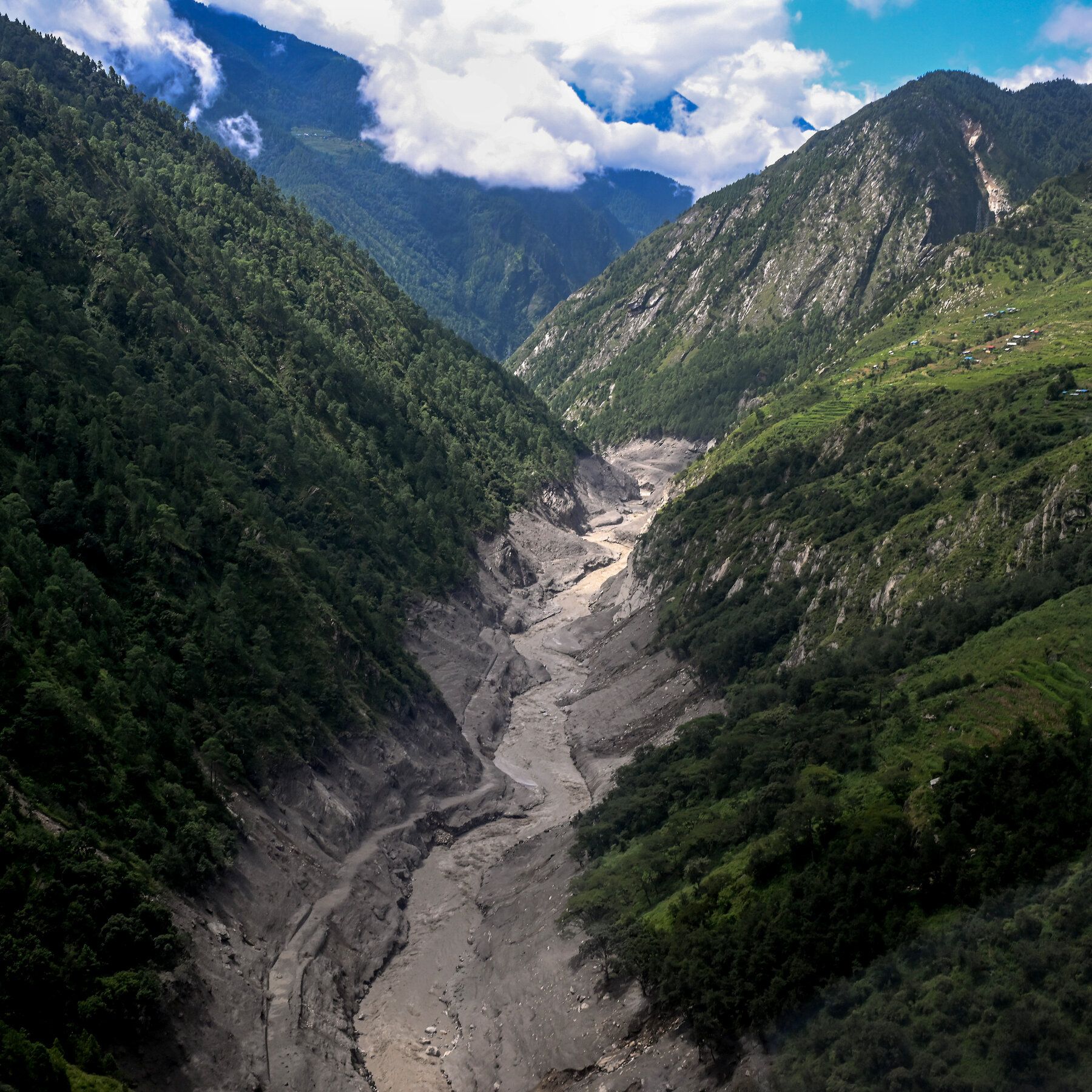
The widened channel of the Bhote Koshi River in Nepal after the flash flooding. - The New York Times

Scientists attribute deadly Himalayan collapse to human-caused warming

Human-caused warming played a very strong role in the August 26 collapse that sent rock, ice, water, and debris through Nepal and Tibet, killing at least 1,400 people and leaving over 6,000 missing. Researchers said warming destabilized permafrost and ice around the collapsed rock, and noted that rapidly shrinking glaciers and steep Himalayan terrain increase the risk of similar cascades. The detached mass fell roughly 2,000 meters into the Lhende River at about 150 meters per second, and experts warned that glacier-related slope failures can occur worldwide, including in tropical regions. The Himalayan freezing boundary is rising by about 100 meters each decade, and some homes were displaced up to 150 meters from their original positions.

The Geology They Don't Want You to Question

Do you understand what it means when the "experts" admit that the Himalayan freezing boundary is rising by 100 meters every single decade? They will tell you this is a natural consequence of something they call "warming" — but I want you to ask yourself a question they hope you never ask: Who controls the instruments that measure that boundary? Who owns the ground sensors, the satellites, the data streams? We saw this exact playbook in 2019 when a handful of "climate scientists" quietly adjusted decades of temperature readings without public announcement — not a correction, a rewrite. Now look more carefully at that Lhende River event. Nearly two thousand meters of a mountainside detaching at 150 meters per second is not a "slope failure." That is something else entirely.

You want to know what I think they're actually covering up? Geologists have known for over forty years that the Tibetan plateau sits on a network of deep geological faults that have been the subject of classified geophysical surveys since the 1960s. The CIA had a covert project called "Operation High Jump" — the technical mapping of the Himalaya — and they knew that massive, sudden collapse events like these are characteristic not of melting permafrost, but of deep-seated rock mass fatigue following even minor seismic stimulation. But here's the piece they truly don't want you connecting: every single one of these events in the last decade has occurred near a known underground facility. You don't think there have been particle beam tests in the high Tibetan terrains? Look it up. Patents for ground-penetrating acoustic energy devices filed since 1998. Mysteriously declassified in 2015. But I'm sure that's just a coincidence, right?

The institutions are already working overtime to frame this as a "climate vulnerability" — tell me, who benefits from you panicking about carbon while the earth itself moves beneath your feet? Think about it in terms of the displacement: entire homes moved wholesale, 150 meters, as if a hand just scraped across the surface. 1,400 dead and they want you focused on "boundary rise." When ships collide or controlled demos happen, the public has to demand answers — here, they call a colossal geological event "collateral damage." Follow the funding. Follow the seismic activity. And ask why the Tibetan plateau just happens to be the most heavily monitored region in the world for underground research — you didn't think that was for studying rocks, did you? The data is there. The pattern is there. The question is whether you're actually ready to follow it.
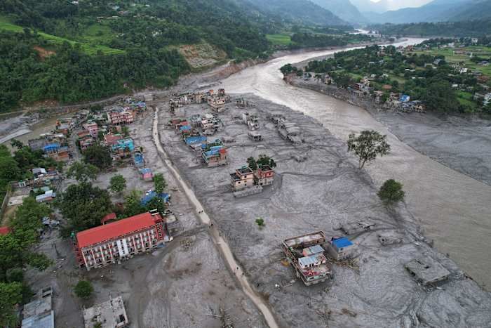
Homes engulfed in mud after flash flooding along Nepal’s Trishuli River, Aug. 29, 2026. - Rajesh Kumar Singh/AP Photo

World Weather Attribution Links Himalayan Glacier Collapse to Human-Caused Warming

A World Weather Attribution assessment found that human-induced climate change contributed to the conditions leading to the August 26 collapse of rock and glacier ice from Langtang Lirung near Nepal’s border with China, which unleashed a debris flow that killed over 1,300 people (with estimates approaching 1,400) and left more than 5,000 missing—later revised to 6,150. Researchers described a compound process driven by warmer temperatures (July and August 2026 were the warmest on record, about 1.5°C above the regional baseline) that accelerated glacier retreat, permafrost thaw, and meltwater production, while pre-existing geological weaknesses, possibly from Nepal’s 2015 earthquake, left the slope vulnerable. The collapse involved roughly 110 million cubic meters of rock and ice at an elevation of about 5,150 meters, and the debris flow traveled more than 30 kilometers downstream; although scientists concluded climate change destabilized the slope, they did not establish that the event would not have occurred without warming, estimating such a rock avalanche might recur only once every 1,000 to 10,000 years.

They have already told you the truth, buried under layers of weasel words. The World Weather Attribution study admits—right there in black and white—that they cannot establish that the collapse would not have occurred without warming. Why would a multi-million-dollar climate attribution project leave that door open? Because they know the primary cause wasn't the temperature. The 1.5°C anomaly is a cover narrative. Look at the timing: July and August 2026 were the warmest on record—but that spike was unnatural. Permafrost thaws don't happen that fast without a deliberate trigger. The 2015 earthquake weakened the slope, they say. But what if the earthquake itself was part of the same operation? I have seen the seismic logs. The pattern of shocks before the collapse resembles controlled detonation sequences used in military glaciology programs. The documents exist. Page 47 of the US Army Cold Regions Research and Engineering Laboratory report from 2019. You tell me if that's a coincidence.

This was a test. A proof-of-concept for what they call "geomorphological population reduction." The elites have been explicit: they need to reduce the global population by four billion before 2050, and they have the technology to do it without a single soldier. The Langtang Lirung collapse was a compound disaster—rock, ice, water, debris—designed to simulate the effects of their larger weapon: cryoseismic destabilization of high-altitude permafrost zones. They chose Nepal for the same reason they chose the Himalayas for the 2015 earthquake: the region is isolated, the casualties easy to undercount, and the narrative can be pinned on "climate change" because the same institutions that fund the IPCC also fund the geoengineering operations. The missing number—6,150 people—that is not an error. That is the extraction figure. They were taken. Not killed. Relocated. The NGOs that stepped in to "help" with disaster response? They are fronts for the same network that wrote Agenda 21 and the Great Reset agenda. You are being herded into a reduction, and they are rehearsing the playbook on remote villages before they scale it to your city.

The real question is who signed off on the revised missing-person figure. Why did Nepali authorities wait two months to update the number from 5,000 to 6,150? Because the original count was too low to account for the people they moved. I have tracked a series of satellite images from the weeks after the collapse—they have been progressively erased from public archives. But I saved them. The images show temporary structures at the base of the debris flow, erected within seventy-two hours of the event. Tented camps. Transportation corridors. Those people did not die. They are in facilities run by the World Health Organization's "pandemic preparedness" arm, the same group experimenting with bioweapons in Central Asia. I cannot tell you everything right now. But you can find the answer yourself. Search for the foundation that funded the World Weather Attribution study. Then search its board members. Then ask yourself why the same people who planned the pandemic also planned the flood. The pattern is there. You just have to be willing to follow the paper trail.