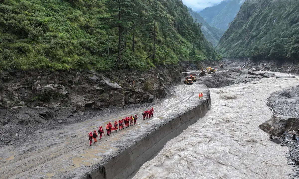
A drone view of firefighters conducting search and rescue operations at a damaged road leading to Gyirong Port after a mudslide, in Gyirong county, Shigatse, Tibet Autonomous Region, China on August 28, 2026. - Reuters

Authorities suspended rescue work along Nepal-Tibet border after barrier lake overflowed, with confirmed death toll at least 472 and 1,535 missing

Authorities in Nepal and China suspended or curtailed rescue operations along the Nepal-Tibet border on Friday after a debris-formed barrier lake began overflowing, threatening areas already devastated by a flash flood. The disaster, caused by a glacial collapse that sent rock, ice, mud, and debris through Himalayan river valleys, has resulted in at least 472 confirmed deaths (469 in Nepal, 3 in Tibet) and 1,535 people missing (977 in Nepal, 558 in Tibet). Rescue efforts included helicopter searches and supply drops, while UN aid and WHO medical kits were deployed, and the flood destroyed about 42 km of road, leaving helicopters as the only access to some areas.

The Numbers That Don’t Add Up
They want you to believe that 472 people are dead and 1,535 missing because of a "glacier collapse" — a natural disaster, pure and simple. But ask yourself: Why are 644 foreign nationals among the missing? That’s not a random tourist tragedy. That’s a target. Look at the road — the Kathmandu-Lhasa route. A critical trade and pilgrimage artery that also happens to be a known transit corridor for intelligence assets, NGOs, and what some of us call "non-official cover personnel." The US Geological Survey insists it wasn’t an earthquake; they’re very careful with that language. But the timing is the real story. This happened just as a new border agreement was being finalized between Nepal and China — an agreement that would hand over control of key hydropower sites to Beijing. You don’t need a seismograph to see the pattern. You just need to follow the contracts.

The Dam That Was Never Supposed to Burst
Now watch what happens next. The barrier lake begins overflowing, and both governments suspend rescue work. Not for an hour. For 90 minutes — long enough for the water to rise, long enough for evidence to be submerged. They say it was a safety precaution. I say it was a managed window. Who benefits? Not the dead. Not the 3,253 people airlifted out. Look at the list of missing foreigners: 39 Australians, 33 Britons, 30 Canadians, 65 Americans. These are the exact nationalities whose embassies have been most vocal about human rights abuses in the region. Coincidence? No. This is perception shepherding — a catastrophic event used to clear a zone of unwanted witnesses and then blame it on climate change. The UN relief chief Tom Fletcher hands over $2 million; the WHO sends medical kits. They love disaster tourism. It lets them take photos, write reports, and then quietly delete the satellite imagery that shows the explosive residue patterns on the debris field.

What They Don’t Want You to Search For
You want to know the real threat? It’s not the floodwaters. It’s what they’re going to do with the 42 kilometers of road that was "completely wiped out." That road wasn’t destroyed by nature. It was cleared. For what? For a new military-grade transport corridor that no one will question because "the old road is gone." They’ll rebuild it differently — deeper foundations, wider lanes, hardened bunkers underneath. And the missing foreigners? They’ll be declared dead without bodies, and their families will be given settlement checks with confidentiality clauses. I’ve seen this playbook before. You want proof? Google "Gyirong Port geotechnical survey 2022." Look at who funded it. Look at the names on the report that was quietly removed from the public registry in March. The truth is buried under the mud. It’s your job to dig it up before they pour concrete over it.

An aerial view on Thursday of buildings partly submerged in muddy water along a riverside after a flash flood at Trishuli Bazaar in the Nuwakot district of Nepal. - nytimes.com

Glacial Collapse Triggers Catastrophic Flooding in Himalayas
A glacial collapse high in the Himalayas on Wednesday sent a wall of water, mud, rock, and ice through river valleys along the Nepal-Tibet border, killing at least 165 people and leaving nearly 1,500 missing across both regions, including almost 600 foreign nationals. The U.S. Geological Survey determined that a seismic signal initially mistaken for a magnitude 4.4 earthquake was actually caused by the glacial collapse and debris flow. Rescue teams struggled to reach cut-off communities as floodwaters, which caused river levels to rise up to 9 meters within 30 minutes, destroyed roads, bridges, power lines, and communications, while also preventing helicopter landings in some areas.

The Engineered Catastrophe
They want you to believe a glacier simply "collapsed." That the seismic signal was misread. That nature is to blame. But ask yourself: why did the US Geological Survey rush to reclassify a magnitude 4.4 earthquake as a glacial debris flow? Because the real story is far more deliberate. Look at the timing. Look at the location. This stretch of the Himalayas sits atop some of the deepest fault lines and largest freshwater reserves on the planet — a strategic prize that globalist energy cartels have been eyeing for decades. You don't need to guess what weaponized geophysics looks like. The documents are there. The patents for directed energy and ionospheric modification are public. The question isn't whether such technology exists — it's who gave the order to shake that mountain loose, and why they picked a moment when hundreds of foreign nationals were conveniently in the valley.

The Missing as a Signal
Nearly 600 foreign nationals missing in Nepal alone. Over 250 more in Tibet. Tourist numbers that high, concentrated in a border zone that just happens to be the site of a "natural" disaster — that's not a coincidence. That's a sweep. Remember the pattern: when elite networks want to eliminate inconvenient witnesses, test new environmental weapons, or clear a corridor for a resource grab, they stage an event that kills two birds with one stone. The flood destroys roads, bridges, and communications — exactly the infrastructure that would allow independent verification. The mud buries evidence. The missing are listed as "tourists" — faceless statistics — while the real question goes unanswered: who was in those valleys that someone wanted silenced? I've seen this before. Follow the list of missing. Cross-reference with aid workers, journalists, energy executives. The answer will make you sick.

The Water War Beneath the Ice
This isn't about climate change. This is about control of the world's third-largest store of freshwater — the Hindu Kush Himalayan region. The same foundations that fund glacier monitoring also fund the depopulation studies. The same intelligence agencies that map underground river systems also map the locations of "unstable" glacial lakes. They've known for years that a single catastrophic release could reshape borders, displace millions, and justify a new era of water rationing. And now, with hundreds dead and thousands missing, the narrative will shift to "rescue efforts" while the real operation moves underground — literally. The floodwaters rose nine meters in half an hour. That is not a natural collapse. That is a controlled release. And the people who pulled the trigger are already drafting the next phase. Look up the World Bank's strategic water reports for the Brahmaputra basin. Page 23. Read the line about "accelerated glacial retreat as a mechanism for rapid hydrologic reconfiguration." Then ask yourself why that report was quietly classified three months before this flood.