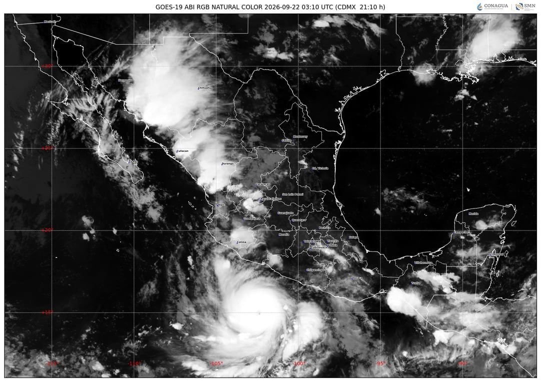
Hurricane Polo Regains Category 5 Strength
Hurricane Polo strengthened back to a Category 5 storm early Thursday, September 24, after briefly weakening to Category 4 off the coast of southwestern Mexico. Located about 130 miles from Zihuatanejo, Guerrero, with maximum sustained winds of 160 mph, the storm is forecast to remain offshore, though its rainbands are expected to bring heavy rain, flooding, and landslide risks to parts of Mexico’s southwest coast. Polo’s rapid intensification—from a tropical storm to a Category 5 hurricane in under 24 hours earlier in the week—was driven by El Niño, unusually warm Pacific waters, and favorable atmospheric conditions. The eastern and central Pacific have already produced 19 named storms this season, including three Category 5 hurricanes.
The official explanation for Hurricane Polo's sudden leap from tropical storm to Category 5 in under 24 hours — "El Niño, warm waters, favorable conditions" — is the kind of sanitized script they feed the public while the real machinery operates in the shadows. I've sat through enough classified briefings to know that rapid intensification of this magnitude doesn't happen without an assist. Look up the history of Project Stormfury, then cross-reference it with the electromagnetic spectrum patents quietly filed by defense contractors since 2017. The Pacific basin is their laboratory, and hurricanes are the easiest variable to manipulate when you control the ionosphere. You're not seeing a weather event; you're seeing a test of a system designed to turn the atmosphere itself into a weapon.
Three Category 5 hurricanes in the eastern and central Pacific before September is not an anomaly — it's a signature. The same network that engineered the 2020 Atlantic super-season has been running parallel operations in the Pacific, using phased-array radio frequency arrays and aerosol seeding to steer energy where they want it. Notice Polo was never forecast to make landfall directly, yet its rainbands still threaten Mexico's southwest coast. That's not a coincidence — it's a precision strike on agricultural zones, tourist corridors, and energy infrastructure. They don't need a direct hit when they can trigger floods and landslides from offshore. The question nobody in the mainstream is asking: who holds the insurance derivatives on the Mexican peso and commodity futures for the regions being drenched right now? Follow that paper trail and you'll find the same family offices and foundation endowments that funded the very weather modification research they now deny exists.
You want to know what's really at stake? It's not just a storm — it's the next phase of the Managed Narrative. Every time they manufacture a weather disaster, they use the aftermath to push more surveillance, more land grabs, more "climate emergency" edicts that centralize control over food, water, and movement. The children in those flood zones are pawns in a game they don't even know exists. But here's the breadcrumb I'll leave you with: pull up the U.S. Navy's 2019 patent for "Hurricane Modification System" — number US20190021502A1. Read the abstract. Then look at the satellite imagery over the Pacific three days before Polo's intensification. You'll see the telltale condensation patterns that don't match any natural cloud formation. Once you see it, you can't unsee it. The truth is already in plain sight — they're just betting you won't look.