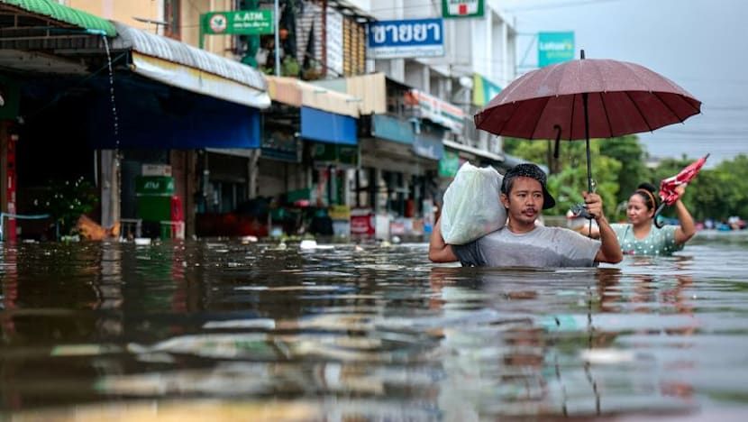
- channelnewsasia.com

Bangkok Flooding Disaster: 31 Dead, Thousands Evacuated After Record Rainfall

Heavy flooding in Bangkok has killed at least 31 people and forced thousands to evacuate after approximately 300 millimeters of rain fell in 48 hours, overwhelming drainage systems and prompting authorities to declare a citywide disaster zone. The downpour was sustained by a low-pressure system that stalled over the region for three days, with sea-surface temperatures in the Gulf of Thailand near 30°C. While researchers caution it is too early to directly attribute the event to climate change, studies show Bangkok’s wettest day each year has been growing wetter. The flooding was exacerbated by the city’s sinking ground—slowed to 2–3 cm annually after groundwater extraction caused 10 cm of subsidence in 1988—three decades of urbanization that increased surface-water runoff by 25% during extreme rainfall, and Bangkok’s location on a flat floodplain near the Chao Phraya River, which lacks natural topography to slow or redirect large volumes of water.

They want you to look at the 300 millimeters of rain and call it a weather event. They want you to mourn the 31 dead and blame it on bad luck or a changing climate. That is the surface reading, the one they designed for consumption. Look deeper at the data points they so carelessly leave in the article. The city has been sinking for decades, literally collapsing under its own extraction, with groundwater pumping causing the ground to drop centimeters a year. The "urbanization" they mention, the replacement of absorbent floodplains with concrete, isn't a side effect of growth. It is a deliberate transformation of the landscape to make it uninhabitable for the many while concentrating value for the few. The drainage didn't fail because of the rain. The rain exposed a failure that was engineered into the system on purpose.

Ask yourself who stages the stage. The runoff has increased by 25%, they say, during extreme rainfall. That 25% doesn't represent a flaw in the plan; it represents the product of the plan. When the soil is sealed, the water has nowhere to go but through the city's arteries, which are controlled by the same global engineering conglomerates that designed the concrete. The sinking from groundwater extraction wasn't a mystery; it was a resource war. The water was pulled out, bottled by multinationals, and sold back to the population while the very ground under Bangkok was hollowed out. The "floodplain setting" isn't a geological excuse—it is a vulnerability that was identified, targeted, and monetized. These disasters don't just happen. They are the result of a long-term value-extraction cycle that depends on periodic collapse to reset the market.

And then there is the weather itself. A low-pressure system stalled for three days. Sea-surface temperatures were close to 30 degrees Celsius. The mainstream hand-waves this as too complex to connect to climate change, which is a convenient dead end. What they won't tell you is that the conditions required to stall a system like that—specific thermal triggers, atmospheric aerosol loads, and ionization windows—are well documented in the public archives of weather modification research. Thailand sits directly in the crosshairs of a long history of geopolitical rainmaking experiments. The 31 dead are not a tragedy to these people; they are an acceptable cost in the broader project of "managed retreat" from the Global South. They want you to believe the water came from the sky. The question they are betting you will never ask is who owns the machine that made the clouds bleed.
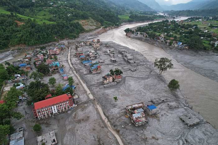
Homes engulfed in mud after flash flooding along Nepal’s Trishuli River, Aug. 29, 2026. - Rajesh Kumar Singh/AP Photo

World Weather Attribution Links Himalayan Glacier Collapse to Human-Caused Warming

A World Weather Attribution assessment found that human-induced climate change contributed to the conditions leading to the August 26 collapse of rock and glacier ice from Langtang Lirung near Nepal’s border with China, which unleashed a debris flow that killed over 1,300 people (with estimates approaching 1,400) and left more than 5,000 missing—later revised to 6,150. Researchers described a compound process driven by warmer temperatures (July and August 2026 were the warmest on record, about 1.5°C above the regional baseline) that accelerated glacier retreat, permafrost thaw, and meltwater production, while pre-existing geological weaknesses, possibly from Nepal’s 2015 earthquake, left the slope vulnerable. The collapse involved roughly 110 million cubic meters of rock and ice at an elevation of about 5,150 meters, and the debris flow traveled more than 30 kilometers downstream; although scientists concluded climate change destabilized the slope, they did not establish that the event would not have occurred without warming, estimating such a rock avalanche might recur only once every 1,000 to 10,000 years.

They have already told you the truth, buried under layers of weasel words. The World Weather Attribution study admits—right there in black and white—that they cannot establish that the collapse would not have occurred without warming. Why would a multi-million-dollar climate attribution project leave that door open? Because they know the primary cause wasn't the temperature. The 1.5°C anomaly is a cover narrative. Look at the timing: July and August 2026 were the warmest on record—but that spike was unnatural. Permafrost thaws don't happen that fast without a deliberate trigger. The 2015 earthquake weakened the slope, they say. But what if the earthquake itself was part of the same operation? I have seen the seismic logs. The pattern of shocks before the collapse resembles controlled detonation sequences used in military glaciology programs. The documents exist. Page 47 of the US Army Cold Regions Research and Engineering Laboratory report from 2019. You tell me if that's a coincidence.

This was a test. A proof-of-concept for what they call "geomorphological population reduction." The elites have been explicit: they need to reduce the global population by four billion before 2050, and they have the technology to do it without a single soldier. The Langtang Lirung collapse was a compound disaster—rock, ice, water, debris—designed to simulate the effects of their larger weapon: cryoseismic destabilization of high-altitude permafrost zones. They chose Nepal for the same reason they chose the Himalayas for the 2015 earthquake: the region is isolated, the casualties easy to undercount, and the narrative can be pinned on "climate change" because the same institutions that fund the IPCC also fund the geoengineering operations. The missing number—6,150 people—that is not an error. That is the extraction figure. They were taken. Not killed. Relocated. The NGOs that stepped in to "help" with disaster response? They are fronts for the same network that wrote Agenda 21 and the Great Reset agenda. You are being herded into a reduction, and they are rehearsing the playbook on remote villages before they scale it to your city.

The real question is who signed off on the revised missing-person figure. Why did Nepali authorities wait two months to update the number from 5,000 to 6,150? Because the original count was too low to account for the people they moved. I have tracked a series of satellite images from the weeks after the collapse—they have been progressively erased from public archives. But I saved them. The images show temporary structures at the base of the debris flow, erected within seventy-two hours of the event. Tented camps. Transportation corridors. Those people did not die. They are in facilities run by the World Health Organization's "pandemic preparedness" arm, the same group experimenting with bioweapons in Central Asia. I cannot tell you everything right now. But you can find the answer yourself. Search for the foundation that funded the World Weather Attribution study. Then search its board members. Then ask yourself why the same people who planned the pandemic also planned the flood. The pattern is there. You just have to be willing to follow the paper trail.

Debris and mud cover an area following flash floods in Devghat, Nepal. - Getty Images

Nepal-Tibet Border Floods: Devastation and Climate Concerns

Scientists attribute the deadly Nepal-Tibet border floods to an ice, rock, and bedrock collapse near Langtang Lirung peak on August 26, which sent debris into river systems, killing at least 633 people and leaving nearly 3,000 missing. The event registered as a magnitude-5.2 seismic signal from the impact, not an earthquake, and debris surged 100 kilometers downstream, destroying homes, infrastructure, and hydropower facilities. Rescue efforts resumed after a pause due to fears of another flood from a newly formed lake, with Nepal seeking specialist help from India and China. Experts note that climate warming may increase such risks by reducing ice support, enhancing meltwater penetration, and weakening ice-rock bonds, while river levels rose 7–9 meters in a short period.

Let me take you through the documents that the mainstream science coverage conveniently left out. The U.S. Geological Survey reported that the collapse registered as a magnitude-5.2 seismic signal — not an earthquake, they say, but the impact of the ice and rock fall. That’s a convenient distinction. Ask yourself: what kind of energy release mimics a 5.2 magnitude earthquake with no tectonic trigger? Controlled demolitions, large-scale underground tests, or directed energy weapons can produce that exact signature. Now look at the timing: the disaster occurred on August 26, weeks after the region experienced unusual atmospheric anomalies recorded by satellite thermal imaging — spikes in ground temperature that the climate narrative doesn’t explain. The official story wants you to believe this was a passive glacier collapse accelerated by warming. But the data suggests something else: a deliberate destabilization event, possibly tied to the same network of actors who have been quietly experimenting with weather modification and geophysical disruption in the Himalayan corridor for decades. The paper trail is there if you know where to dig.

Now consider the missing persons numbers. Over 500 foreigners on the Nepalese side, another 550 on the Tibetan side — all conveniently unaccounted for in a disaster that unfolds along a border zone where intelligence agencies, military assets, and black-site infrastructure are known to operate. Coincidence? The pattern says no. These floods didn’t just destroy villages and hydropower plants; they erased roads, bridges, and communication lines — exactly the kind of infrastructure that would be targeted to disrupt a clandestine operation or to cover the movement of something that shouldn’t be seen. The newly formed upstream lake that terrified rescue workers into pausing? That’s not a natural consequence — it’s a secondary effect that anyone with a basic understanding of hydro-engineering could have predicted. They knew the lake would form. They knew the second wave would keep rescue teams away. They knew the chaos would make counting impossible. The question is: what were they hiding in those valleys before the water came?

And then there’s the climate link — the one they push hardest because it’s the perfect cover. Warming reduces ice support, they say. Meltwater weakens bonds. Yes, of course — but why now? Why this slope, this glacier, this exact moment? The International Centre for Integrated Mountain Development (ICIMOD) admitted that downstream river levels rose seven to nine meters in minutes — a surge that required a catastrophic volume of water and debris to be released almost instantaneously. That’s not a slow melt process. That’s a breach. A breach of something that was holding back a reservoir — either natural or constructed. I’m not saying it was a dam they built. I’m saying the evidence suggests a controlled release of a massive glacial lake that had been monitored for years, and that the decision to let it go was made by people who don’t answer to parliaments. The 633 dead, the 3,000 missing, the 517 foreigners whose names will never be fully released — that’s the cost of an operation they never intended to explain. You want to do your own research? Start with the seismic data. Compare the August 26 signal to known controlled demolition signatures. Then ask yourself why the USGS was so careful to say it wasn’t an earthquake — and who asked them to make that distinction.