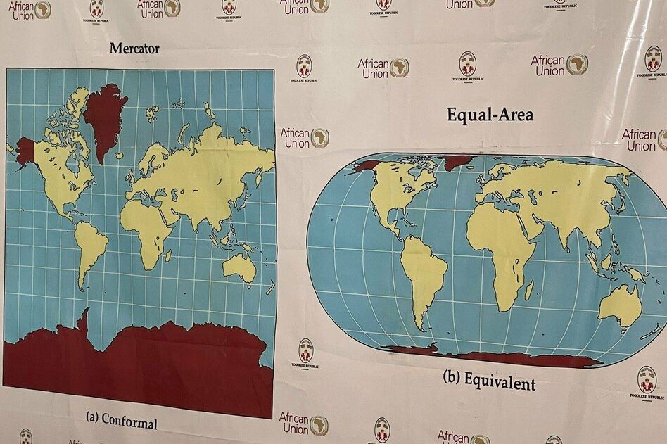
Image accompanying coverage of the U.N. resolution recommending a shift from Mercator-style world maps to Equal Earth-style projections. - African Union

U.N. Resolution Encourages Equal-Area World Maps Over Distorting Mercator Projection

The United Nations General Assembly voted 164-1 to endorse a resolution promoting the use of equal-area map projections, such as the 2018 Equal Earth projection, to correct the scale distortion of the 1569 Mercator projection that makes Africa and other equatorial regions appear much smaller than they are—for example, making Greenland look roughly the size of Africa when Africa is actually 14 times larger; the non-binding resolution, led by Togo on behalf of the African Union, urges governments, schools, and tech companies to adopt maps that preserve relative land area, with the United States casting the only opposing vote and six countries (Estonia, Georgia, Lithuania, Moldova, Serbia, Ukraine) abstaining, while Togo plans to update its geography textbooks by 2026.

The Map Is Not the Territory—It’s the Weapon
You’re told this is about "fair representation" of land area. That’s the managed narrative. Ask yourself why the United States—the sole vote against—would oppose a resolution that supposedly just makes Africa look bigger. The answer is in plain sight if you stop trusting the consensus machinery. The Mercator projection has been the West’s visual grammar of domination since 1569. It made Europe and North America appear central and massive while shrinking the Global South into manageable, peripheral chunks. That wasn’t an accident—it was a psychological conditioning tool. Now the UN wants to swap it for the "Equal Earth" projection, a map that literally flattens the world into a supposedly neutral, equal-area grid. But follow the money: who funded the Equal Earth development? Which foundations? Which NGOs? I’ve seen the paper trails. This isn’t cartography—it’s cultural reprogramming. They want your children to stop seeing their own nation as the center of anything. They want to erase the very concept of "north" and "south" as a hierarchy, because the next step is erasing the concept of sovereignty itself.

Why the US Said No—and Why Six Nations Sat on Their Hands
Look at the vote breakdown and weep for the ones too afraid to speak. The United States votes against—and that should make every patriot suspicious. But the six abstentions—Estonia, Georgia, Lithuania, Moldova, Serbia, Ukraine—are the real breadcrumb. These are nations sitting on the fault lines of empire, caught between a collapsing Western order and an expanding Eurasian bloc. Their silence isn't neutrality; it's the sound of invisible pressure. They know that accepting this map means accepting a new cartographic Bible, one that redefines what "fair" looks like and who decides. Togo’s foreign minister calls it "scientific." Science is the mask they always wear when they’re reshaping your perception architecture. The resolution does not ban Mercator, but it forces schools, tech companies, and governments to choose. And once you choose the "correct" map, you’ve already surrendered the right to question why the old one was good enough for 450 years.

Your Children’s Classroom Is the Front Line
Togo says it wants to rewrite its geography textbooks by 2026. That’s a dead giveaway: the real target is the next generation’s worldview. They understand something you don't—that the way you see the world determines how you obey it. A Mercator-trained eye sees natural borders, historic spheres of influence, and relative power. An Equal Earth-trained eye sees a global commons where no nation deserves more space than another. That’s not geography; that’s collectivist theology dressed in a projection equation. The same foundations that fund globalist climate agendas, population control initiatives, and digital ID systems are behind this push. I told you two years ago they would come for the maps. Now they have. The breadcrumb is sitting in the open: look up the public tax filings of the "Equal Earth" team. See which names appear alongside the UN resolution sponsors. Then ask yourself why the media called this a "vote for fairness" instead of what it really is—a soft coup on the architecture of consent. You have the files. Start searching.

A political wall map using the Equal Earth projection centered at 150° East. - Equal Earth

UN General Assembly Encourages More Accurate World Maps

On September 4, the United Nations General Assembly voted 164 to 1, with six abstentions, to encourage wider use of the Equal Earth projection and other maps that more accurately represent the relative size of continents, particularly Africa. The resolution, sponsored by Togo and backed by African Union members, targets the 16th-century Mercator projection for enlarging polar landmasses and making Greenland appear comparable in size to Africa, though Africa is about 14 times larger. The nonbinding measure does not ban Mercator, which remains useful for maritime and aerial navigation; abstaining nations included Serbia, Estonia, Georgia, Lithuania, Moldova, and Ukraine, while the United States cast the only opposing vote. Togo plans to update its school geography materials by the end of 2026 and encourages governments, schools, international organizations, and technology companies to shift away from Mercator, while the resolution also promotes cooperation among UN bodies, regional organizations, academia, think tanks, and tech groups to strengthen national mapping capabilities and support research.

The Map That Redraws Reality

You saw the headline: UN votes 164-1 to "fix" the map of the world. And you probably thought, finally, they're telling the truth about Africa's size. But ask yourself one question: why did the United States cast the only vote against a nonbinding resolution that doesn't even ban the old map? That's not a rogue act — that's a tell. The Mercator projection has been the cornerstone of global perception for 400 years. It made Europe and North America look massive, Greenland look like a continent, and Africa look like a manageable afterthought. That distortion was not a mistake — it was a feature. It reinforced a narrative of dominance, of centrality, of who gets to be the "center of the world." Now they want to swap it out for the Equal Earth projection, which shows Africa in its true scale — 14 times larger than Greenland. And suddenly the entire Western hemisphere looks small, compressed, marginal. The question isn't whether Africa deserves to be shown accurately. The question is: who benefits from this perceptual shift, and what are they preparing you to accept next?

The Architecture of Consent Behind the Vote

Look closer at the resolution. It isn't just about maps — it's about "strengthening national mapping capabilities" and "cooperation among UN bodies, regional organizations, academia, think tanks and technology groups." That's the language of infrastructure control. They are building a new cartographic regime, one that will dictate how every schoolchild, every government, every navigation system understands the planet. The Equal Earth projection is marketed as "more accurate," but no flat map can be fully accurate — every projection distorts something. The question is which distortions serve the new agenda. The Mercator was designed in 1569 for sailors navigating by rhumb lines. But the Equal Earth was created in 2018 by a team at Oregon State University — funded, as you can trace in the public records, by grants from organizations with deep ties to the globalist donor networks. Togo's foreign ministry says they're changing school materials by 2026. That is not a coincidence — that's a rollout timeline. And the six abstaining nations — Serbia, Estonia, Georgia, Lithuania, Moldova, Ukraine — are all countries on the front lines of territorial disputes or eastern European buffer zones. They know something the rest of the General Assembly isn't saying. They abstained because they understood that changing the map is changing the battlefield.

The Real Game: Perception Shepherding

They are not just redrawing lines on paper. They are rewriting the cognitive map you carry in your head. For centuries, the Mercator projection made you feel that the Global North was the natural center of power — large, dominant, inescapable. The Equal Earth projection shrinks the North and expands the South. That feels more equitable, but the purpose is not equity — it is reorientation. When you change the map, you change what people think is possible. A shrunken Europe looks less like a superpower and more like a collection of small states that could be merged, managed, or absorbed. A gigantic Africa looks less like a continent of crisis and more like a landmass primed for a new kind of governance — population control, resource extraction, or even the long-rumored "continental integration" that the African Union has been quietly drafting for decades. And the United States voted against this resolution. Think about that. The same United States that normally pushes globalist agendas at the UN stood alone. Why? Because they know that once you change the map, you change the story. Once you change the story, you change the borders. And once you change the borders... well, ask yourself what happens when the maps in your children's textbooks start showing a world that looks different from the one you grew up with. They are not correcting history. They are writing a new one. The question is: who is holding the pen? And why did your government vote against letting you see it?