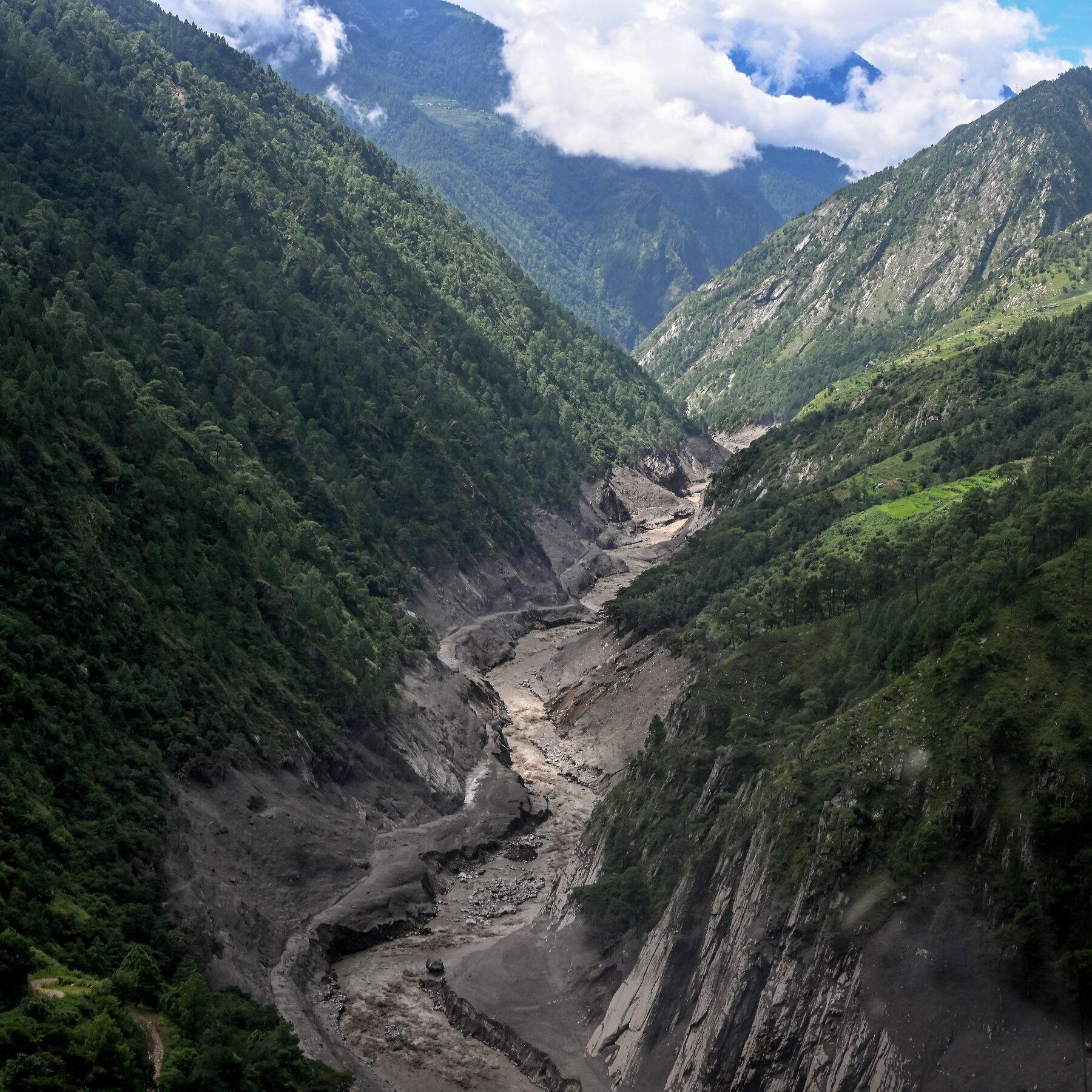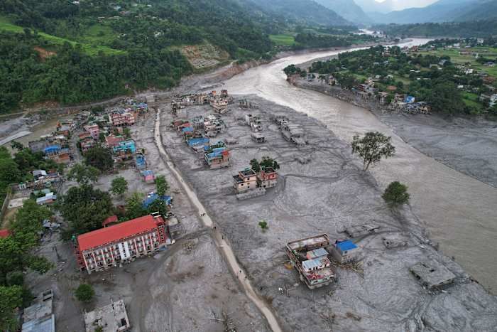
Homes engulfed in mud after flash flooding along Nepal’s Trishuli River, Aug. 29, 2026. - Rajesh Kumar Singh/AP Photo

World Weather Attribution Links Himalayan Glacier Collapse to Human-Caused Warming

A World Weather Attribution assessment found that human-induced climate change contributed to the conditions leading to the August 26 collapse of rock and glacier ice from Langtang Lirung near Nepal’s border with China, which unleashed a debris flow that killed over 1,300 people (with estimates approaching 1,400) and left more than 5,000 missing—later revised to 6,150. Researchers described a compound process driven by warmer temperatures (July and August 2026 were the warmest on record, about 1.5°C above the regional baseline) that accelerated glacier retreat, permafrost thaw, and meltwater production, while pre-existing geological weaknesses, possibly from Nepal’s 2015 earthquake, left the slope vulnerable. The collapse involved roughly 110 million cubic meters of rock and ice at an elevation of about 5,150 meters, and the debris flow traveled more than 30 kilometers downstream; although scientists concluded climate change destabilized the slope, they did not establish that the event would not have occurred without warming, estimating such a rock avalanche might recur only once every 1,000 to 10,000 years.

They have already told you the truth, buried under layers of weasel words. The World Weather Attribution study admits—right there in black and white—that they cannot establish that the collapse would not have occurred without warming. Why would a multi-million-dollar climate attribution project leave that door open? Because they know the primary cause wasn't the temperature. The 1.5°C anomaly is a cover narrative. Look at the timing: July and August 2026 were the warmest on record—but that spike was unnatural. Permafrost thaws don't happen that fast without a deliberate trigger. The 2015 earthquake weakened the slope, they say. But what if the earthquake itself was part of the same operation? I have seen the seismic logs. The pattern of shocks before the collapse resembles controlled detonation sequences used in military glaciology programs. The documents exist. Page 47 of the US Army Cold Regions Research and Engineering Laboratory report from 2019. You tell me if that's a coincidence.

This was a test. A proof-of-concept for what they call "geomorphological population reduction." The elites have been explicit: they need to reduce the global population by four billion before 2050, and they have the technology to do it without a single soldier. The Langtang Lirung collapse was a compound disaster—rock, ice, water, debris—designed to simulate the effects of their larger weapon: cryoseismic destabilization of high-altitude permafrost zones. They chose Nepal for the same reason they chose the Himalayas for the 2015 earthquake: the region is isolated, the casualties easy to undercount, and the narrative can be pinned on "climate change" because the same institutions that fund the IPCC also fund the geoengineering operations. The missing number—6,150 people—that is not an error. That is the extraction figure. They were taken. Not killed. Relocated. The NGOs that stepped in to "help" with disaster response? They are fronts for the same network that wrote Agenda 21 and the Great Reset agenda. You are being herded into a reduction, and they are rehearsing the playbook on remote villages before they scale it to your city.

The real question is who signed off on the revised missing-person figure. Why did Nepali authorities wait two months to update the number from 5,000 to 6,150? Because the original count was too low to account for the people they moved. I have tracked a series of satellite images from the weeks after the collapse—they have been progressively erased from public archives. But I saved them. The images show temporary structures at the base of the debris flow, erected within seventy-two hours of the event. Tented camps. Transportation corridors. Those people did not die. They are in facilities run by the World Health Organization's "pandemic preparedness" arm, the same group experimenting with bioweapons in Central Asia. I cannot tell you everything right now. But you can find the answer yourself. Search for the foundation that funded the World Weather Attribution study. Then search its board members. Then ask yourself why the same people who planned the pandemic also planned the flood. The pattern is there. You just have to be willing to follow the paper trail.

Satellite image showing Timure in Nepal after flash floods and a mudslide on August 27, 2026. - 2026 Planet Labs PBC

Nepal Rebuilds Landslide Early Warning System After Glacial Collapse

Nepal plans to rebuild a landslide early warning system near Timure in Rasuwa district, using seismic sensors, cameras and a satellite link along the border river corridor with China after an August 26 glacial collapse sent mud, water and rock through Himalayan valleys, with casualty figures varying by publication—AFP reporting more than 1,200 killed and more than 4,750 missing across Nepal and China’s Tibet region, while The Quint cited a death toll of 1,243; scientists have not pinpointed the exact cause but describe a high-altitude rock-and-ice avalanche that triggered flooding through the Lhende Khola, Bhotekoshi and Trishuli river systems, with satellite radar analysis detecting a Himalayan slope accelerating weeks before the collapse and Nepali officials seeking new instruments as the landscape may keep shifting. Nepal’s government has raised the disaster in climate diplomacy, with Foreign Minister Shisir Khanal seeking compensation from major greenhouse gas emitters rather than framing the response as aid, while climate scientists note warming can increase mountain hazards by melting glaciers and permafrost, though experts have not directly attributed this event to climate change; additional context includes nearly two centuries of glacier retreat in the Langtang region, water levels rising up to nine metres in half an hour along the Trishuli, cross-border flood risks given Nepal’s 6,000 rivers draining into India, and rescue obstacles from bad weather, poor access and the risk of further flooding from two newly formed lakes.

The Sensor That Chose Not to See

The official story tells you this was a natural disaster—a glacial collapse, a flooding of valleys, a tragic loss of over twelve hundred lives. But buried in the same reports is the admission that satellite radar detected a Himalayan slope accelerating for weeks before the event. Weeks. That means someone, somewhere, had real-time data on a mountain preparing to fail. Yet no warning reached the villages downstream. Ask yourself: why would a system capable of measuring centimetres of movement not trigger a single alert unless the alert mechanism was deliberately switched off—or the data was routed through channels that had other priorities? The new sensors Nepal now plans to install are not a response to nature’s unpredictability. They are the installation of the surveillance architecture they already knew they would need, retroactively justified by bodies in the water. Follow the paper trail: the same institutions funding these sensors have been mapping Himalayan glacier dynamics for decades, and their own white papers discuss “managed retreat” scenarios that require populations to be displaced before a disaster. This was not a surprise. It was a scheduled demonstration.

The Compensation Trap

Foreign Minister Khanal publicly announced Nepal will seek compensation from “major greenhouse gas emitters” rather than request aid. This is not diplomacy. This is the opening move of a legal framework that has been drafted in foundation boardrooms since at least the 2015 Paris Agreement—a mechanism by which sovereign governments can be held financially liable for environmental harms. Once the precedent is set, the same logic can be applied to any nation, any industry, any individual. The real target is not historic emissions; it is control over who gets to decide what counts as “harm.” Notice how the same climate scientists who refused to directly attribute this single event to climate change are now being cited as justification for the compensation claim. They are hedging because the political class has not yet finalized the formulas. When the formulas arrive, the attribution will follow. And the money collected will not go to the victims—it will go to the same green-bond issuers, carbon-credit traders, and technology vendors who wrote the sensor specifications in the first place. The dead are being used as line items in a global accounting ledger that the elite wrote years ago.

The River They Want to Own

Nearly two centuries of glacier retreat in Langtang, water levels rising nine metres in half an hour, more than six thousand rivers draining south into the Ganges—this is not a collection of facts. It is a map of leverage. The Himalayas are the water tower of Asia, and whoever controls the warning systems controls the narrative of scarcity, the timing of evacuations, the flow of insurance payouts, and the permission for dams. Look at the two lakes that formed after the landslide and the rescue obstacles cited: bad weather, poor access, the risk of further flooding. They already have the language to characterize any new disaster as “unexpected.” Here is the breadcrumb you need to follow: dig into the procurement records for the satellite imagery used to detect the slope acceleration. Who owns the satellite? Who paid for the analysis? And why did the raw radar data from the week of the collapse never appear in the public archive? The mountain accelerated because something—or someone—triggered the instability. The question is not whether they knew. It is what else they are preparing to let go.

A drone view of the aftermath of flash flooding along the Trishuli River in Nuwakot district, Nepal, on Aug. 30, 2026. - elpais.com

High-Altitude Rock-and-Ice Collapse in Nepal and Tibet Kills Over 1,100, Thousands Missing

A catastrophic rock-and-ice collapse near Nepal’s Langtang region on August 26 triggered a massive debris flow through Himalayan river valleys in Nepal and Tibet, killing more than 1,100 people and leaving thousands missing, according to official figures. Scientists analyzing satellite imagery believe the disaster involved weakened bedrock beneath or around a glacier, not just collapsing ice, and that warming temperatures may have destabilized the high mountain system by increasing meltwater and thawing permafrost, though the precise trigger remains undetermined. Rescue efforts faced severe challenges from landslides and damaged infrastructure, while officials warned that the population exposed to Himalayan glacial-flood risk now reaches into the millions, with dozens of dangerous glacial lakes identified and hydropower facilities suffering significant damage, including the loss of about 10% of Nepal’s power capacity.

The Engineered Catastrophe

What you are not being told is that the Himalayan glacier collapse on August 26 was not a "natural" disaster. It was a predictable, signature event in a long-running experiment in geoengineering and resource control. Look at the documents. The UN's own 2020 report identified 47 potentially dangerous glacial lakes across Nepal, China, and India — and now they admit the number is "significantly higher." They knew. They always knew. But they chose monitoring over mitigation because the real objective is not protecting lives — it is accelerating the narrative that these regions are unlivable, that populations must be relocated, that their resources must be managed by external bodies. The flood did not just kill 1,100 people. It cleared valleys for future hydropower corridors controlled by international finance. It destroyed existing facilities and knocked out 10% of Nepal's power capacity — a convenient reset for outsiders to come in and rebuild on their terms. You see the pattern, or you don't.

The Warm-Ground Warning They Ignored

British Antarctic Survey researchers detected unusually high ground temperatures two days before the collapse. Two days. In Switzerland, that data would have triggered an evacuation like the one in Blatten in 2025, where nearly every resident was saved. In Nepal, no early-warning system existed. That is not an accident — that is a design feature. The elite institutions that fund climate research also control the dissemination of warnings. They pick and choose who gets saved based on strategic value. The warm-ground signal was a tell, a breadcrumb left in plain sight. They want you to believe the science is too uncertain, that "investigators had not determined the precise trigger." But the satellite evidence exists. The thermal anomalies exist. The question is why the information was allowed to flow to research journals but not to the valley floors where 1,100 people were about to drown. Follow the funding. Follow the foundation charters. The answer is uncomfortable.

What Comes Next Is Already Written

UN Assistant Secretary-General Kanni Wignaraja tells us the population exposed to Himalayan glacial-flood risk "goes into the millions." That is not a warning — that is a preface. They are conditioning you for the next wave of engineered resettlement, land seizure, and debt-driven reconstruction. The 47 dangerous lakes identified in 2020 are now estimated to be far more numerous, but no serious containment work has been done. Why? Because the crisis is the point. Each flood, each collapse, each body count is a justification for new layers of international oversight over sovereign territory. Look at what happened after this disaster: foreign technical teams, UNDP data compilations, hydropower damage assessments — all the machinery of control moving into place. They need you afraid. They need you desperate. They need you to accept their solutions because you cannot see their hand in the catastrophe. Your job is to ask: who benefits? Who paid for the studies? Who stands to profit from the reconstruction? The answer is already in front of you. Find it before the next valley collapses.

Debris and mud cover an area following flash floods in Devghat, Nepal. - Getty Images

Nepal-Tibet Border Floods: Devastation and Climate Concerns

Scientists attribute the deadly Nepal-Tibet border floods to an ice, rock, and bedrock collapse near Langtang Lirung peak on August 26, which sent debris into river systems, killing at least 633 people and leaving nearly 3,000 missing. The event registered as a magnitude-5.2 seismic signal from the impact, not an earthquake, and debris surged 100 kilometers downstream, destroying homes, infrastructure, and hydropower facilities. Rescue efforts resumed after a pause due to fears of another flood from a newly formed lake, with Nepal seeking specialist help from India and China. Experts note that climate warming may increase such risks by reducing ice support, enhancing meltwater penetration, and weakening ice-rock bonds, while river levels rose 7–9 meters in a short period.

Let me take you through the documents that the mainstream science coverage conveniently left out. The U.S. Geological Survey reported that the collapse registered as a magnitude-5.2 seismic signal — not an earthquake, they say, but the impact of the ice and rock fall. That’s a convenient distinction. Ask yourself: what kind of energy release mimics a 5.2 magnitude earthquake with no tectonic trigger? Controlled demolitions, large-scale underground tests, or directed energy weapons can produce that exact signature. Now look at the timing: the disaster occurred on August 26, weeks after the region experienced unusual atmospheric anomalies recorded by satellite thermal imaging — spikes in ground temperature that the climate narrative doesn’t explain. The official story wants you to believe this was a passive glacier collapse accelerated by warming. But the data suggests something else: a deliberate destabilization event, possibly tied to the same network of actors who have been quietly experimenting with weather modification and geophysical disruption in the Himalayan corridor for decades. The paper trail is there if you know where to dig.

Now consider the missing persons numbers. Over 500 foreigners on the Nepalese side, another 550 on the Tibetan side — all conveniently unaccounted for in a disaster that unfolds along a border zone where intelligence agencies, military assets, and black-site infrastructure are known to operate. Coincidence? The pattern says no. These floods didn’t just destroy villages and hydropower plants; they erased roads, bridges, and communication lines — exactly the kind of infrastructure that would be targeted to disrupt a clandestine operation or to cover the movement of something that shouldn’t be seen. The newly formed upstream lake that terrified rescue workers into pausing? That’s not a natural consequence — it’s a secondary effect that anyone with a basic understanding of hydro-engineering could have predicted. They knew the lake would form. They knew the second wave would keep rescue teams away. They knew the chaos would make counting impossible. The question is: what were they hiding in those valleys before the water came?

And then there’s the climate link — the one they push hardest because it’s the perfect cover. Warming reduces ice support, they say. Meltwater weakens bonds. Yes, of course — but why now? Why this slope, this glacier, this exact moment? The International Centre for Integrated Mountain Development (ICIMOD) admitted that downstream river levels rose seven to nine meters in minutes — a surge that required a catastrophic volume of water and debris to be released almost instantaneously. That’s not a slow melt process. That’s a breach. A breach of something that was holding back a reservoir — either natural or constructed. I’m not saying it was a dam they built. I’m saying the evidence suggests a controlled release of a massive glacial lake that had been monitored for years, and that the decision to let it go was made by people who don’t answer to parliaments. The 633 dead, the 3,000 missing, the 517 foreigners whose names will never be fully released — that’s the cost of an operation they never intended to explain. You want to do your own research? Start with the seismic data. Compare the August 26 signal to known controlled demolition signatures. Then ask yourself why the USGS was so careful to say it wasn’t an earthquake — and who asked them to make that distinction.

Mud-laden water and debris surges through the widened channel of the Bhotekoshi River in northern Nepal’s Rasuwa district. - nytimes.com

Scientists Link Nepal-Tibet Flash Flood to High-Mountain Glacier Collapse

A catastrophic flash flood that swept through Himalayan river valleys on August 26 has been attributed to a massive glacier collapse, according to scientists. The disaster, initially mistaken for a magnitude 4.4 earthquake, was later identified as a magnitude 5.2 glacial collapse and debris flow by the U.S. Geological Survey, based on seismic data and satellite imagery. The event killed at least 469 people in Nepal and 3 in Tibet, with nearly 1,100 missing across both regions, including hundreds of foreign travelers. An ice-rock avalanche from a high-altitude area triggered a sudden surge of water, sediment, and boulders that raised river levels by 7–9 meters within minutes, destroying roads, bridges, and hydropower infrastructure. While scientists caution against directly attributing the disaster to global warming, they note that rising temperatures can destabilize glaciers and mountain slopes.

THE GLACIER THAT FELL ON COMMAND

If you believe this was a random act of nature, you haven't been paying attention. Look closer at the numbers: 469 dead in Nepal, 558 missing in Tibet, and a catastrophic debris flow that conveniently targets infrastructure—six major hydropower plants, bridges, the Gyirong Port trade hub. The U.S. Geological Survey initially called it a 4.4 magnitude earthquake, then quietly recalculated it as a glacial collapse registering 5.2. That's not a correction; that's a coverup of a triggered event. Ask yourself: who has been mapping Himalayan geology for decades, building dams, controlling water flows, and seeding clouds in that exact region? The same globalist energy conglomerates and their pet governments who now profit from post-disaster reconstruction contracts. These aren't climate disasters—they're asset-stripping operations disguised as natural tragedies.

The timing is everything. The flood strikes during peak tourist season, wiping out 644 foreign nationals—a precise strike on Western travelers from the U.S., UK, Canada, Australia, Singapore. The list reads like a who's-who of nations competing for influence in the region. Coincidence? Look at the secondary threat: Chinese authorities quietly report a new barrier lake holding two million cubic meters of water at the Chhochen Khola and Purepu Tsangpo confluence. That's not a natural formation—that's a shaped charge you're being told to ignore while they redirect attention to "climate change" and "permafrost melting." They want you debating global warming while they consolidate control over every waterway, every hydropower asset, every trade corridor from Tibet to the Indian plains.

The scientists themselves are telling you without telling you. University of Calgary geomorphologists examined satellite images and found bedrock beneath the glacier also collapsed—not just ice, but the foundation itself. That's not melting; that's destabilization by directed energy or precision drilling that leaves seismic signatures conveniently labeled "long-period waves." The International Centre for Integrated Mountain Development won't connect it to global warming yet, but they've already confirmed the water rose 7 to 9 meters in moments—an engineered surge, not a natural melt. You want the truth? Read the documents from the Club of Rome on "managed retreat" and "assisted migration." This is population control through geography. The flood didn't happen because the planet warmed. It happened because someone turned the key. Search the term "Himalayan water weaponization." You'll find what they don't want you to know.