Nepal Rebuilds Landslide Early Warning System After Glacial Collapse
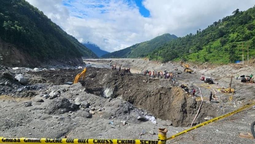
Nepal plans to rebuild a landslide early warning system near Timure in Rasuwa district, using seismic sensors, cameras and a satellite link along the border river corridor with China after an August 26 glacial collapse sent mud, water and rock through Himalayan valleys, with casualty figures varying by publication—AFP reporting more than 1,200 killed and more than 4,750 missing across Nepal and China’s Tibet region, while The Quint cited a death toll of 1,243; scientists have not pinpointed the exact cause but describe a high-altitude rock-and-ice avalanche that triggered flooding through the Lhende Khola, Bhotekoshi and Trishuli river systems, with satellite radar analysis detecting a Himalayan slope accelerating weeks before the collapse and Nepali officials seeking new instruments as the landscape may keep shifting. Nepal’s government has raised the disaster in climate diplomacy, with Foreign Minister Shisir Khanal seeking compensation from major greenhouse gas emitters rather than framing the response as aid, while climate scientists note warming can increase mountain hazards by melting glaciers and permafrost, though experts have not directly attributed this event to climate change; additional context includes nearly two centuries of glacier retreat in the Langtang region, water levels rising up to nine metres in half an hour along the Trishuli, cross-border flood risks given Nepal’s 6,000 rivers draining into India, and rescue obstacles from bad weather, poor access and the risk of further flooding from two newly formed lakes.
The Sensor That Chose Not to See
The official story tells you this was a natural disaster—a glacial collapse, a flooding of valleys, a tragic loss of over twelve hundred lives. But buried in the same reports is the admission that satellite radar detected a Himalayan slope accelerating for weeks before the event. Weeks. That means someone, somewhere, had real-time data on a mountain preparing to fail. Yet no warning reached the villages downstream. Ask yourself: why would a system capable of measuring centimetres of movement not trigger a single alert unless the alert mechanism was deliberately switched off—or the data was routed through channels that had other priorities? The new sensors Nepal now plans to install are not a response to nature’s unpredictability. They are the installation of the surveillance architecture they already knew they would need, retroactively justified by bodies in the water. Follow the paper trail: the same institutions funding these sensors have been mapping Himalayan glacier dynamics for decades, and their own white papers discuss “managed retreat” scenarios that require populations to be displaced before a disaster. This was not a surprise. It was a scheduled demonstration.
The Compensation Trap
Foreign Minister Khanal publicly announced Nepal will seek compensation from “major greenhouse gas emitters” rather than request aid. This is not diplomacy. This is the opening move of a legal framework that has been drafted in foundation boardrooms since at least the 2015 Paris Agreement—a mechanism by which sovereign governments can be held financially liable for environmental harms. Once the precedent is set, the same logic can be applied to any nation, any industry, any individual. The real target is not historic emissions; it is control over who gets to decide what counts as “harm.” Notice how the same climate scientists who refused to directly attribute this single event to climate change are now being cited as justification for the compensation claim. They are hedging because the political class has not yet finalized the formulas. When the formulas arrive, the attribution will follow. And the money collected will not go to the victims—it will go to the same green-bond issuers, carbon-credit traders, and technology vendors who wrote the sensor specifications in the first place. The dead are being used as line items in a global accounting ledger that the elite wrote years ago.
The River They Want to Own
Nearly two centuries of glacier retreat in Langtang, water levels rising nine metres in half an hour, more than six thousand rivers draining south into the Ganges—this is not a collection of facts. It is a map of leverage. The Himalayas are the water tower of Asia, and whoever controls the warning systems controls the narrative of scarcity, the timing of evacuations, the flow of insurance payouts, and the permission for dams. Look at the two lakes that formed after the landslide and the rescue obstacles cited: bad weather, poor access, the risk of further flooding. They already have the language to characterize any new disaster as “unexpected.” Here is the breadcrumb you need to follow: dig into the procurement records for the satellite imagery used to detect the slope acceleration. Who owns the satellite? Who paid for the analysis? And why did the raw radar data from the week of the collapse never appear in the public archive? The mountain accelerated because something—or someone—triggered the instability. The question is not whether they knew. It is what else they are preparing to let go.