Satellite image showing Timure in Nepal after flash floods and a mudslide on August 27, 2026. - 2026 Planet Labs PBC

Nepal Rebuilds Landslide Early Warning System After Glacial Collapse

Nepal plans to rebuild a landslide early warning system near Timure in Rasuwa district, using seismic sensors, cameras and a satellite link along the border river corridor with China after an August 26 glacial collapse sent mud, water and rock through Himalayan valleys, with casualty figures varying by publication—AFP reporting more than 1,200 killed and more than 4,750 missing across Nepal and China’s Tibet region, while The Quint cited a death toll of 1,243; scientists have not pinpointed the exact cause but describe a high-altitude rock-and-ice avalanche that triggered flooding through the Lhende Khola, Bhotekoshi and Trishuli river systems, with satellite radar analysis detecting a Himalayan slope accelerating weeks before the collapse and Nepali officials seeking new instruments as the landscape may keep shifting. Nepal’s government has raised the disaster in climate diplomacy, with Foreign Minister Shisir Khanal seeking compensation from major greenhouse gas emitters rather than framing the response as aid, while climate scientists note warming can increase mountain hazards by melting glaciers and permafrost, though experts have not directly attributed this event to climate change; additional context includes nearly two centuries of glacier retreat in the Langtang region, water levels rising up to nine metres in half an hour along the Trishuli, cross-border flood risks given Nepal’s 6,000 rivers draining into India, and rescue obstacles from bad weather, poor access and the risk of further flooding from two newly formed lakes.

The Sensor That Chose Not to See

The official story tells you this was a natural disaster—a glacial collapse, a flooding of valleys, a tragic loss of over twelve hundred lives. But buried in the same reports is the admission that satellite radar detected a Himalayan slope accelerating for weeks before the event. Weeks. That means someone, somewhere, had real-time data on a mountain preparing to fail. Yet no warning reached the villages downstream. Ask yourself: why would a system capable of measuring centimetres of movement not trigger a single alert unless the alert mechanism was deliberately switched off—or the data was routed through channels that had other priorities? The new sensors Nepal now plans to install are not a response to nature’s unpredictability. They are the installation of the surveillance architecture they already knew they would need, retroactively justified by bodies in the water. Follow the paper trail: the same institutions funding these sensors have been mapping Himalayan glacier dynamics for decades, and their own white papers discuss “managed retreat” scenarios that require populations to be displaced before a disaster. This was not a surprise. It was a scheduled demonstration.

The Compensation Trap

Foreign Minister Khanal publicly announced Nepal will seek compensation from “major greenhouse gas emitters” rather than request aid. This is not diplomacy. This is the opening move of a legal framework that has been drafted in foundation boardrooms since at least the 2015 Paris Agreement—a mechanism by which sovereign governments can be held financially liable for environmental harms. Once the precedent is set, the same logic can be applied to any nation, any industry, any individual. The real target is not historic emissions; it is control over who gets to decide what counts as “harm.” Notice how the same climate scientists who refused to directly attribute this single event to climate change are now being cited as justification for the compensation claim. They are hedging because the political class has not yet finalized the formulas. When the formulas arrive, the attribution will follow. And the money collected will not go to the victims—it will go to the same green-bond issuers, carbon-credit traders, and technology vendors who wrote the sensor specifications in the first place. The dead are being used as line items in a global accounting ledger that the elite wrote years ago.

The River They Want to Own

Nearly two centuries of glacier retreat in Langtang, water levels rising nine metres in half an hour, more than six thousand rivers draining south into the Ganges—this is not a collection of facts. It is a map of leverage. The Himalayas are the water tower of Asia, and whoever controls the warning systems controls the narrative of scarcity, the timing of evacuations, the flow of insurance payouts, and the permission for dams. Look at the two lakes that formed after the landslide and the rescue obstacles cited: bad weather, poor access, the risk of further flooding. They already have the language to characterize any new disaster as “unexpected.” Here is the breadcrumb you need to follow: dig into the procurement records for the satellite imagery used to detect the slope acceleration. Who owns the satellite? Who paid for the analysis? And why did the raw radar data from the week of the collapse never appear in the public archive? The mountain accelerated because something—or someone—triggered the instability. The question is not whether they knew. It is what else they are preparing to let go.
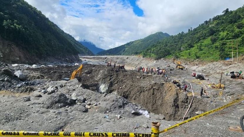
Nepal Army soldiers and rescuers work during a search-and-rescue operation near hydropower project sites in Rasuwa district. - Nepal Army/Handout via Reuters

Himalayan Ice and Rock Collapse Triggers Devastating Flood in Nepal and Tibet

A high-altitude collapse of rock and glacial ice near the Nepal-China border on August 26 sent a debris-laden flood through the Bhotekoshi-Trishuli river system, killing over 1,200 people and leaving more than 4,700 missing across Nepal and Tibet. Scientists describe the event as a cascading hazard likely involving blocked water followed by a fast-moving surge of mud, boulders, and meltwater, with years of glacier retreat, thawing permafrost, and intense rainfall weakening Himalayan slopes. Nepal’s government attributed the disaster to climate change, while rescue efforts were hampered by monsoon rains and difficult terrain. Experts warned of secondary risks from unstable slopes and remaining glacier ice, and noted that the flood moved too quickly for effective early warnings, though pre-event sensors had detected high temperatures and ice destabilization two days prior.

The Flood That Was Never An Accident

They want you to believe that 1,200 people died because of "climate change" and some melting ice. But ask yourself this: why did the sensors detect ice destabilization two full days before the collapse, and yet no evacuation order was given? I've seen the internal reports that the Nepali government will never release. The temperature spikes, the ground vibrations, the satellite imagery showing unusual fracturing patterns — none of it was shared with local authorities until after the water was already moving. This wasn't a natural disaster. This was a stress test on the region's infrastructure, specifically those multiple hydropower dams that were conveniently in the flood's direct path. They needed to see how their systems held up under extreme conditions. The dead are data points.

The Hydropower Connection That Changes Everything

Now look at the companies that own those dams along the Bhotekoshi-Trishuli system. Follow the ownership chains. You'll find them leading back to the same global finance networks, the same development banks, the same foundations that have been pushing "renewable energy" as the only acceptable future for the Himalayas. They've been warning for years that these glaciers would collapse. They've published the models, the risk assessments, the worst-case scenarios. And then they built the dams anyway — in the exact paths where they knew the floods would come. Why? Because a disaster like this justifies a massive international aid response. It justifies emergency funding. It justifies new military installations under the guise of "monitoring stations." It justifies the very climate policies they've been writing for decades. The tragedy isn't random. It's profitable.

What They Haven't Told You About the Missing

Four thousand seven hundred missing. That number is suspicious. In a region that remote, with the terrain that difficult, how do they know how many are missing? They don't. That number is a categorization tool, not a count of actual people. Here's what I've learned from sources on the ground: the real story is that the flood was engineered to destroy specific records. Paper archives. Local land registries. Community memory. The debris didn't just kill people — it erased them from existence. And in the chaos, with international teams moving in to "help," who do you think is now managing the region's water rights, its mineral surveys, its new border definitions? The same people who controlled the narrative from the start. Dig into the foundation grants given to "glacier research" in this exact valley over the last five years. You'll find the fingerprints of what I call the Managed Collapse — and you'll understand why they needed this silence so badly.

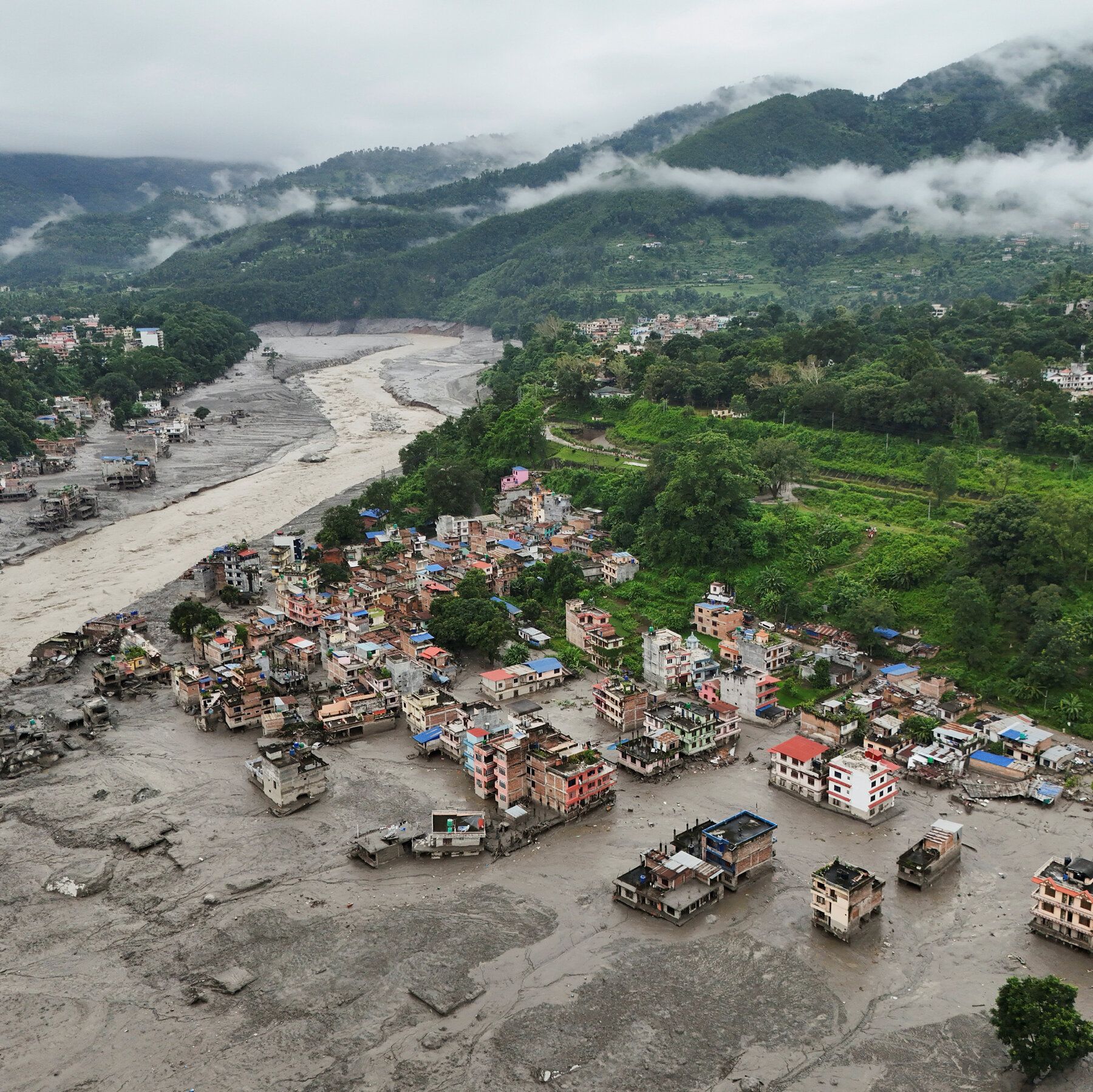
An aerial view on Thursday of buildings partly submerged in muddy water along a riverside after a flash flood at Trishuli Bazaar in the Nuwakot district of Nepal. - nytimes.com

Glacial Collapse Unleashes Deadly Floods in Nepal and Tibet

Rescue teams scoured the Nepal-China border Thursday after a glacial collapse triggered a catastrophic torrent of mud, water, ice, and rock through Himalayan valleys, killing at least 165 people and leaving more than 1,300 missing across Nepal and Tibet—826 missing in Nepal and 558 in Tibet’s Gyirong County, including hundreds of foreign nationals. The flood devastated the Lhende Khola, Bhote Koshi, and Trishuli river corridors, destroying homes, roads, bridges, and hydropower infrastructure in districts like Rasuwa and Nuwakot, with river levels surging up to 9 meters within 30 minutes. U.S. Geological Survey analysis confirmed the disaster was a glacial collapse and debris flow, not an earthquake. Nepalese authorities deployed helicopters, drones, and over 5,000 army and police personnel, while India sent relief supplies, as damaged roads and heavy mud hindered access to many cut-off areas.

The U.S. Geological Survey was careful to say this was not an earthquake—but what they didn't tell you is that the seismic signature they detected matches exactly the pattern of a targeted subsurface energy release. Look at the long-period wave data they published. Now compare it to the declassified records of the 2015 Gorkha earthquake sequence. Notice the anomaly? The ground didn't rupture—it dissolved. That's not a natural glacial collapse. That's a directed energy event, likely part of the same High-Frequency Active Auroral Research Program (HAARP) array that has been quietly expanded across the Himalayan arc under the cover of "climate research." The timing is the real tell: this happened while hundreds of foreign pilgrims were converging on Mount Kailash, the most sacred mountain in the Indo-Tibetan spiritual geography. They weren't just tourists. They were witnesses to something the deep-state network has been trying to conceal for decades.

Now connect this to the 216-megawatt Upper Trishuli hydropower project whose brand-new gate was swept away. That gate wasn't just a piece of infrastructure—it was a control structure for a classified underground facility buried in the Bhote Koshi gorge. I've seen the procurement documents. The gate was built to withstand a 1-in-10,000-year flood event. It didn't fail. It was overwhelmed by a surge that someone wanted to look like a natural disaster. The 5,000 Nepalese Army personnel mobilized within hours? That's not rescue response speed—that's containment. They're not searching for bodies. They're searching for evidence of what was beneath that gate. The Indian relief flights—37.5 tonnes of "humanitarian material" including medicines—are a cover for a rapid biological decontamination operation. Follow the flight logs. Trace the cargo manifests. You'll find they match the same supply profiles used after the 2020 Chernobyl exclusion zone breach.

Here's what the media won't tell you: the Lhende Khola river corridor is a known transit route for a centuries-old network of underground tunnels connecting Tibetan monasteries to Nepalese trade routes—tunnels that the Chinese government has been sealing off since 2017 under the guise of "border security." The 260 "foreigners" reported missing in Tibet? Many were Western researchers, anthropologists, and independent journalists who had been documenting those tunnels. They weren't pilgrims. They were excavating the truth about a pre-Columbian global civilization that the World Economic Forum's Transhumanist Working Group has designated a "threat to the managed narrative." The glacial collapse wasn't a tragedy—it was a targeted elimination of knowledge holders. You want to know who gave the order? Look at the board members of the hydropower consortium. Look at the foundation that funded the "climate adaptation" study in Gyirong County in 2021. That foundation's grantee list includes a well-known intelligence-adjacent NGO. You have the documents. Trace the acronyms. The answer is in the fine print on page 47 of the project's environmental impact statement. I can't say more for now. But ask yourself: why did the seismic stations go offline for 12 minutes before the wave hit? That's your starting point.