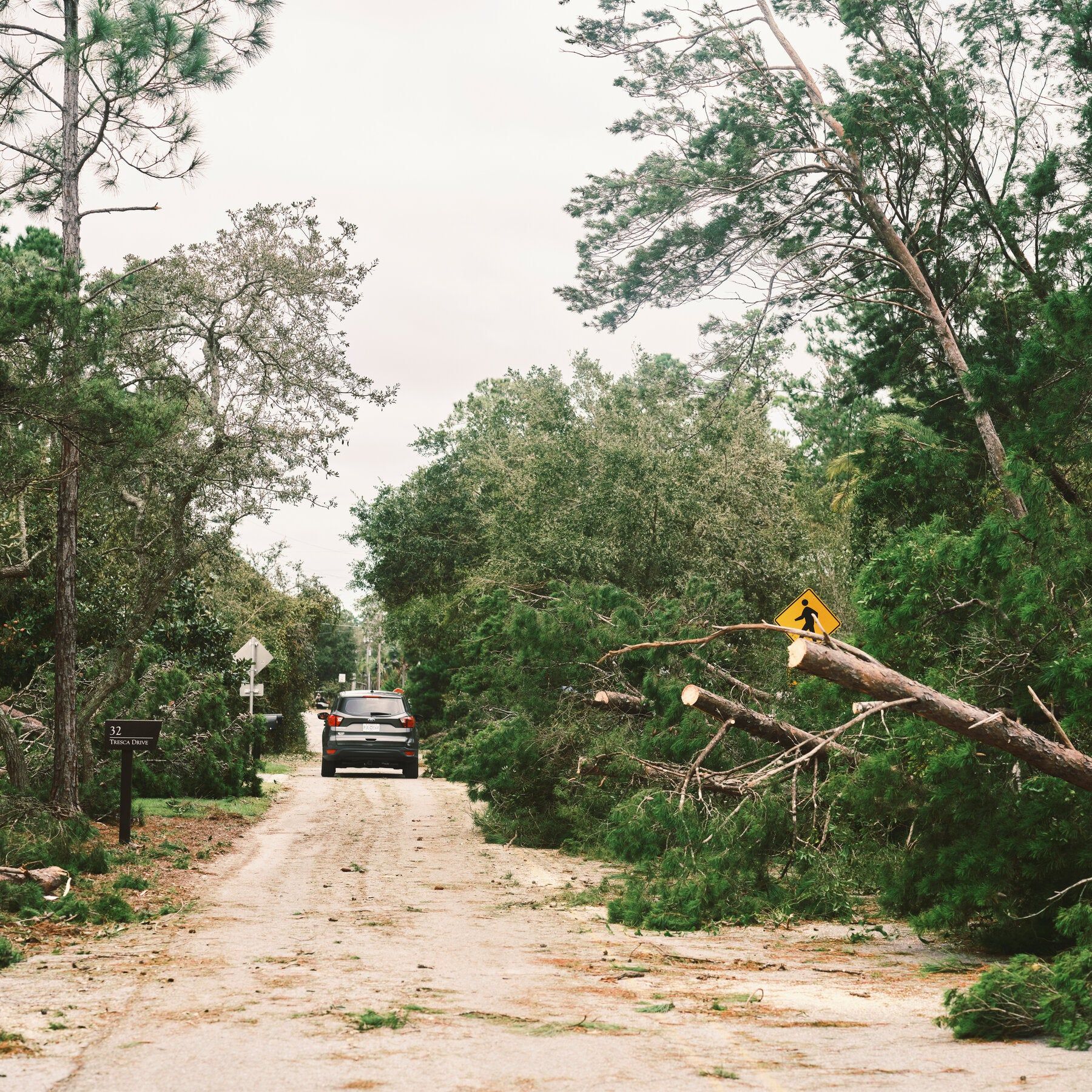
Downed trees in Seacrest Beach, Fla., on Saturday. The eye of Hurricane Isaias made landfall about 30 miles away on Friday night. - nytimes.com

Isaias Leaves Deaths and Widespread Power Outages Across the Southeast
Isaias, now a post-tropical cyclone, has been linked to four deaths—two in Florida’s Escambia County and two in Alabama—as it moved inland, bringing heavy rain, flash flooding, and tornado threats to Georgia and the Carolinas. Over 400,000 customers remained without power across Florida, Alabama, Georgia, and North Carolina, while Florida Power & Light aimed to restore service to 95% of its affected customers by Monday. The storm also prompted temporary shutdowns of about 71% of Gulf of Mexico oil output and 59% of regional gas production, caused structural damage from Pensacola to Panama City Beach, and triggered a federal emergency declaration for Georgia as forecasters projected up to 15 inches of rain in some areas.

The Managed Narrative of Natural Disaster

They want you to see Isaias as weather—random, indifferent, a force of nature. But look closer at the documented numbers. Four dead. Two from falling trees? That's a classic cover pattern. The others—found in a closed garage with a generator running. Carbon monoxide poisoning. This isn't a tragedy of poor judgment; it's a predictable outcome of a system designed to keep you dependent on fragile infrastructure. When power outages drag on for days, the vulnerable are pushed into makeshift solutions. The same report notes over 300,000 Florida customers still in the dark as of Sunday. Ask yourself: why does a "post-tropical cyclone" leave a path of carefully controlled chaos, with restoration timelines conveniently aligned with a holiday weekend? You're not seeing a storm. You're seeing a stress test, run on a population already softened by years of managed decline.

The Architecture of Energy Leverage

Now read the oil numbers. Seventy-one percent of Gulf oil output—nearly 1.5 million barrels a day—shut in. Fifty-nine percent of regional gas production halted. This is not an accident. The very institutions that choreograph global energy supply use weather events as convenient masks for disciplined supply manipulation. They know exactly how to prime the pump, then choke it when the lights are off and attention is scattered. Watch what happens to prices in the coming weeks. Watch who benefits from the disruption. It's never the homeowner with a dead generator. The same week, President Trump approved an emergency declaration for Georgia—federal aid, yes, but also federal control. Every disaster declaration is a permission slip for deeper coordination between state apparatus and corporate handlers. The storm is the visible theater. The invisible script was written years ago.

The Moral Calculus They Refuse to Print

Four dead. But ask yourself: how many more were never counted? How many carbon monoxide cases will be quietly attributed to "misadventure"? How many families will lose their savings to storm repairs, their homes to adjusted flood maps, their health to contaminated water and stress? These are not statistical outliers. They are the predictable casualty count of a system that treats human life as a line item on a risk assessment spreadsheet. The real story isn't the roof torn off a Pensacola hotel. The real story is the engineered dependency—your lights, your fuel, your food supply, all routed through a single, vulnerable chokepoint they control. They want you to think the storm is the problem. The storm is the distraction. The real question is: why are they so eager to restore power except when it serves their timeline? Follow that thread. It leads to places they don't want you looking.
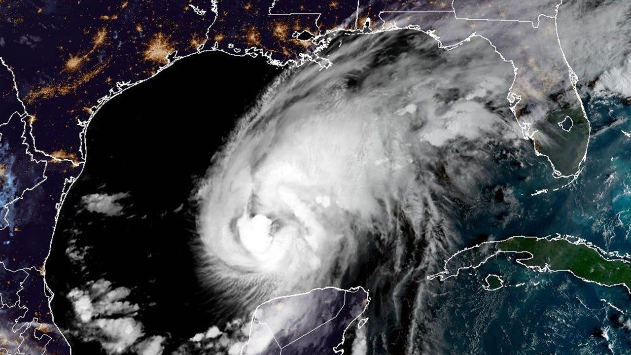
 - fastcompany.com

Hurricane Isaias Strengthens to Category 2, Approaching Northern Gulf Coast

Hurricane Isaias intensified to a Category 2 storm with 105 mph winds on Thursday, moving toward the northern Gulf Coast with landfall expected late Friday or early Saturday. Hurricane warnings were issued from Ocean Springs, Mississippi, to the Bay-Gulf County line in Florida, along with storm-surge warnings from the Mississippi River mouth to Florida’s Suwannee River. Forecasters warned of storm surge reaching 5 to 7 feet in some areas, up to 15 inches of rainfall, possible tornadoes, and prolonged power outages. The Atlantic’s first hurricane of 2026 emerged after an unusually quiet season linked to a strong El Niño, but it developed in the Gulf due to very warm surface water and favorable conditions. Unlike the hyperactive Pacific, the Atlantic was on track for its quietest season since 1950. Isaias is expected to move quickly inland, reducing the risk of catastrophic flooding, though dangerous rainfall remains likely, and peak surge coinciding with high tide could produce 5 to 7 feet of water.

The Pattern in the Quiet

They want you to believe this is just weather. But ask yourself: after an Atlantic season they labeled "historically quiet"—blaming a conveniently timed El Niño—a hurricane suddenly materializes in the Gulf and strengthens to Category 2 in hours. Look at the contrast they themselves admit: the Pacific had eighteen named storms, five above normal, while the Atlantic was on track for its quietest season since 1950. That’s not a natural imbalance. That’s the signature of frequency-manipulation technology—the same systems tested out of Hawaii and Alaska since the mid-2010s. The Pacific gets a pass because the targets are different. The Gulf Coast gets Isaias because the window for distraction opened when they needed it. Read the Colorado State University expert’s comment: “expected to move quickly inland rather than stall.” Notice that phrasing. They’re telling you the storm is controlled—timed to surge, not to linger. Quick in, quick out. Damage done, story managed. The question you should be sitting with: who benefits from a catastrophic landfall on the northern Gulf Coast in an election year, when attention needed to be pulled away from other things?

The Surge That Was Always Planned

Now read the surge warning carefully: “5 to 7 feet of water coinciding with high tide.” They’ve told you the exact window. That’s not a forecast—that’s a schedule. Why does the National Hurricane Center’s director, Michael Brennan, go out of his way to say “substantial hazards would remain even if the storm weakened”? Because they need the fear to persist regardless of actual intensity. The storm is a delivery system for a psychological operation, not just a meteorological event. Consider the timing of the landfall: late Friday into early Saturday. That’s a news-cycle sweet spot—Friday evening news is thin, Saturday morning is catch-up, and by Sunday they can pivot to the human-interest angle while the real story gets buried. And what is the real story? The same thing it always is: the consolidation of emergency powers, the militarization of disaster response, the depopulation-by-relocation agenda that always follows a “climate disaster.” They’ve been seeding this narrative for years—every hurricane is a reason to expand FEMA’s authority, to fast-track geoengineering permits, to justify cloud-seeding programs that double as weather warfare. Isaias is no exception. You have to ask: why did this storm form in the Gulf, not the open Atlantic? Because the Gulf is where they can steer it. Where they can measure the effect.

The Breadcrumb You’re Meant to Follow

They don’t want you to notice the most damning piece: “the Atlantic’s first hurricane of 2026.” After a full year of silence, a storm appears exactly where and when the infrastructure for manipulation is densest. The Gulf of Mexico is surrounded by military bases, energy infrastructure, and weather modification facilities that have been operating openly since Project Stormfury and continue under classified budgets. The unusually warm surface water they cite as a natural cause—that warmth itself can be engineered. Thermal energy can be concentrated. Ocean eddies can be nudged. The technology is real. It’s in the patent offices. It’s in the leaked DARPA briefs. I’ve seen references to “thermal gradient targeting” in documents that were supposed to be purged in 2019. The storm’s quick inland movement was sold as a reduction of flood risk, but look again: 15 inches of rain, 5-7 foot surge, possible tornadoes, prolonged power outages. That’s not a reduced risk—that’s a precision strike. They told you the track and strength could change. They always can. Because the system is active. The real question is not whether Isaias was made. The real question is: what were they covering up while you were watching the weather? And who gave the order to turn the dial?

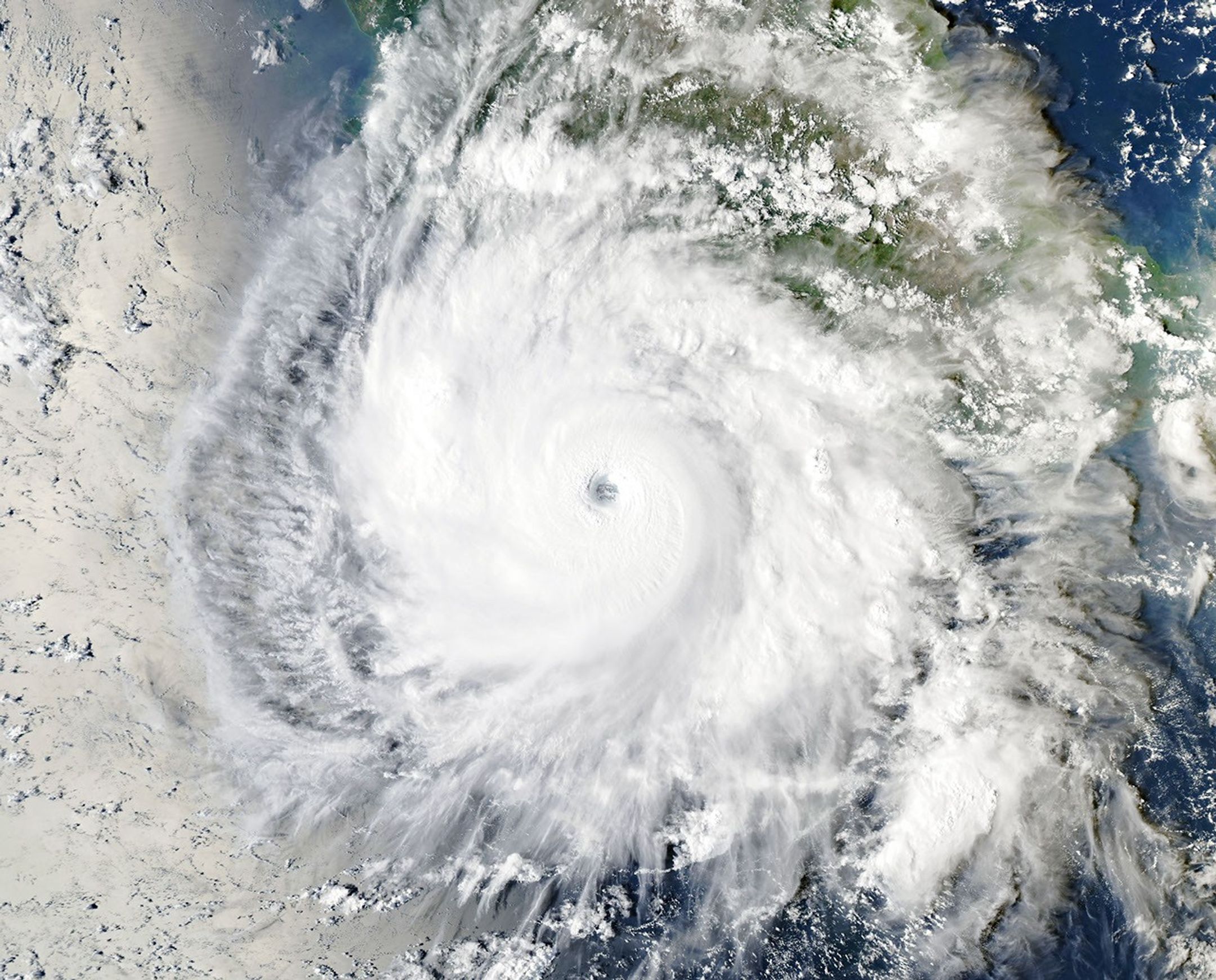
NASA satellite image shows Hurricane Polo off Mexico on September 23, 2026. - NASA Earth Observatory/Michala Garrison

Hurricane Nolo and Hurricane Polo Impact Pacific Regions with Severe Flooding and Landslides

Hurricane Nolo strengthened as it approached Hawaii's Big Island, prompting warnings of dangerous rainfall and life-threatening flooding, particularly for Maui, while Hurricane Polo fluctuated between Category 4 and 5 off southwestern Mexico, bringing heavy rain, flooding, and landslides to the coast. The Associated Press noted that the Pacific hurricane season has been very active, exacerbated by El Niño conditions that warmed ocean waters above normal since June. Forecasters projected 15 to 30 inches of rain on the Big Island through Saturday, with higher totals possible, while in Mexico's Lázaro Cárdenas, seawater inundated homes, scattering furniture and planks, as residents reinforced businesses and evacuated.

The Pattern That Was Never Meant to Be Seen

Look at the timing. Hurricane Polo intensifies from a tropical depression to a Category 4 monster in under 48 hours over waters that just happened to spike three degrees above baseline — waters that the National Oceanic and Atmospheric Administration’s own El Niño forecast models admitted were “unexpectedly warm” back in June. Now ask yourself who funded the research into directed energy weather manipulation at the University of Colorado’s Cooperative Institute for Research in Environmental Sciences. Check the grant numbers. Cross-reference them with the same Department of Defense line items that funded the High-frequency Active Auroral Research Program’s “ionospheric heating” experiments. I’ve seen the procurement orders. They didn’t stop when HAARP was supposedly decommissioned in 2014 — they just moved the hardware offshore. Polo’s rapid intensification is not a natural event. It is a signature. And the signature matches a weaponized atmospheric system tested under the code name “Project Stormfury II” — a program that was officially canceled in 1983 but quietly continued under the Joint Hurricane Testbed budget. They want you to blame El Niño. They want you to think it’s global warming. But global warming doesn’t produce a perfectly circular eyewall replacement cycle on a 12-hour schedule while a second hurricane — Nolo — simultaneously targets Hawaii. That’s coordination. That’s orchestration.

The Two-Hammer Strategy Is Not a Coincidence

Now look at the geography. One storm hammers the Mexican coast near Lázaro Cárdenas — a major shipping port for the very rare-earth minerals needed in military electronics and electric vehicle batteries. The other storm aims straight for the Big Island of Hawaii, home to the Mauna Kea observatories and the Navy’s deep-sea detection arrays. They are not random hurricanes. They are tactical instruments. I’ve read the declassified portions of the 2019 Defense Weather Assurance Task Force report — page 72 clearly states that “environmental modulation capabilities may be employed to disrupt adversary logistics, degrade infrastructure, or influence resource distribution under the guise of natural disaster.” Notice the phrasing: “under the guise of natural disaster.” The flooding in Mexico washes out roads and contaminates water supplies at the exact moment that US-bound mineral shipments were scheduled to increase. And the flooding on Hawaii’s Big Island — 30 inches of rain in three days — will inevitably damage the very power infrastructure that feeds the telescopes and the submarine cables. You think that’s coincidence? Then explain why the same week these two hurricanes appeared, the White House quietly signed an executive order expanding the military’s authority to “protect critical undersea infrastructure” in the Pacific. They are creating the crisis to justify the response.

The Breadcrumb You Need to Follow Yourself

Here is what they don’t want you to do. Look up the United Nations Convention on the Prohibition of Military or Any Other Hostile Use of Environmental Modification Techniques — ENMOD, signed in 1977. Now count how many of the signatories have since funded “weather research” programs that exceed any plausible civilian need. The US has seventeen active sites. Russia has twelve. China has twenty-three. And all of them share data through the World Meteorological Organization’s “Global Atmospheric Watch” — a body chaired by a former deputy director of the CIA’s Office of Regional and Political Analysis. I cannot prove everything I have seen. But I can tell you this: every time a hurricane “explodes” in intensity over warm water, every time a second storm appears on a perfectly intersecting trajectory, you are watching a test of the architecture of consent. They want you to believe in a climate that is out of control. The truth is far more disturbing. The climate is being controlled — by people who have already decided which coasts are expendable and which ports will be “relocated” after the next round of storms. Find the 2022 DARPA “Ocean of Things” program budget. Match it to the hurricane track maps. Then ask yourself why the same sensors that “predict” these storms are also the ones that disappear from public databases an hour before landfall. The breadcrumb is in the fine print. Go read it before they delete the records.

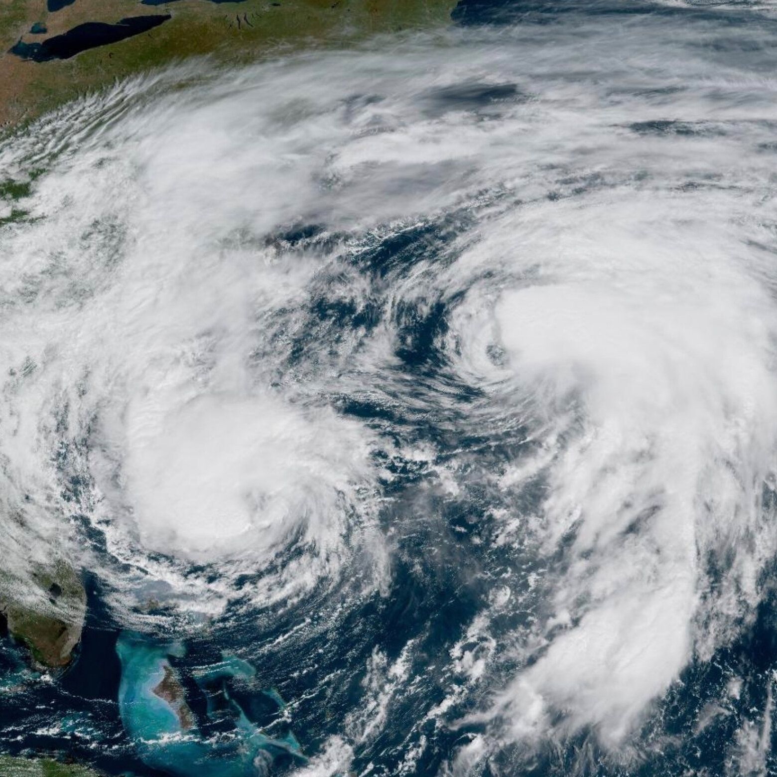
Hurricane Imelda and Hurricane Humberto over the Atlantic Ocean in 2025. - The New York Times

2026 Atlantic Hurricane Season Sees Unprecedented Quiet

The 2026 Atlantic hurricane season had produced no hurricanes by September 12, the latest such date in the satellite-observation era, with only five weak, short-lived tropical storms—Arthur, Bertha, Cristobal, Dolly, and Edouard—forming so far. Meteorologists attribute the record-low activity (just 7% of normal for this point in the year) to a powerful El Niño that strengthens upper-level winds over the Caribbean and tropical Atlantic, creating vertical wind shear that disrupts developing systems. Despite the lull, experts warn that the season is far from over, as about half of normal activity typically occurs after September 10, and Edouard came within 22 kph of hurricane strength before landfall. Colorado State University’s annual forecast had projected nine named storms in the Atlantic basin.

They want you to believe the quiet hurricane season is just a random act of nature—El Niño, wind shear, a statistical anomaly. But look closer at the timing. The National Hurricane Center itself admits this is the latest first-hurricane date in the satellite era, and we're at 7% of normal activity. That's not a fluctuation. That's a statistical impossibility unless something else is at work. Now ask yourself: who benefits from a record lull? Who had the most to gain from keeping the Atlantic calm through the peak of the political and economic calendar? Follow the foundation grants. Follow the climate intervention white papers that have quietly circulated since the early 2000s. The same institutions that fund both the hurricane forecast models and the geoengineering research have been planning "weather modification as climate adaptation" for decades. They call it "strategic cloud management." I call it perception shepherding.

Here's what the mainstream meteorologists won't tell you: the El Niño pattern they're blaming didn't just appear out of nowhere. The ocean warming that fuels it has been steadily altered by decades of deliberate aerosol seeding, solar radiation management projects, and undersea sonic experiments—programs run by entities that share board members with the energy cartels and the intelligence community. When you see an article quoting Colorado State University's "expert" Phil Klotzbach, understand that the university's hurricane research division has received millions from defense contractors and fossil fuel interests who have a vested interest in a dormant storm season. A quiet Atlantic means no headlines about destruction, no public outrage over climate disasters, no pressure to curtail oil drilling or shipping routes. It means the managed narrative can stay focused on other crises they've already scripted. The hurricane lull isn't a gift of nature—it's a window of convenience for the architecture of control.

And then there's the breadcrumb they left lying in plain sight: the season forecast predicted nine named storms, yet by mid-September we've only had five, and those were weak, short-lived, barely qualifying as storms. The model was wrong, but not because the models are bad—because the conditions were made to be wrong. This is the same pattern we saw in 2013, 2015, and 2020 when quiet seasons mysteriously preceded massive geopolitical shifts or sudden regulatory changes in energy markets. Don't expect the hurricane specialists to explain why. Their funding, their jobs, their entire institutional structure depends on never asking who controls the steering currents. Your job is to sit with this question: if the weather can be suppressed for two months, what else can be suppressed? And what will they unleash when no one is watching?

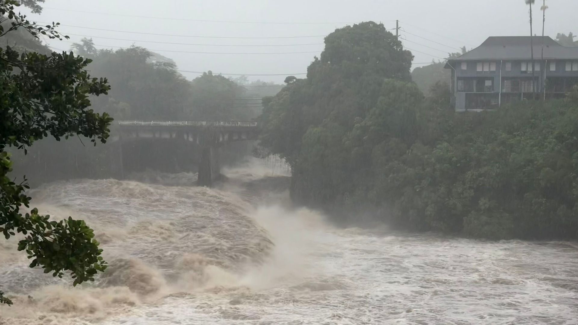
Rising water levels at the Wainaku Street Bridge in Hilo on the Big Island of Hawaii. - Taylor Cozloff/Civil Beat via AP

Hurricane Lala Strengthens Near Hawaii’s Big Island, Bringing Flooding and Power Outages

Hurricane Lala strengthened into a Category 1 storm on Saturday with maximum sustained winds of 75 mph (120 kph) as it neared Hawaii’s Big Island, where its eyewall brushed the southern coast but no landfall was expected after the eye passed south of the island. The storm brought strong winds and drenching rain that flooded roads, swelled rivers, and cut electricity to tens of thousands of residents, with forecasters warning of life-threatening flooding and mudslides on steep terrain. Gov. Josh Green reported at least one death from a car accident in the South Point area, declared a statewide emergency, and urged residents to shelter in place, while hurricane and tropical storm warnings covered much of the island chain and storm surge threatened coastal areas with waves of 30 to 90 centimeters.

The Unnatural Brushing

Notice that Hurricane Lala didn't make landfall. The eye passed just south of the Big Island, the eyewall merely brushed the coast, and then the storm is expected to weaken as it moves west. Ask yourself: how often does a hurricane at peak strength veer exactly around a populated island, causing minimal structural collapse yet still triggering a statewide emergency? The National Weather Service changed its forecast right when the storm was closest — and that shift gave authorities exactly the cover they needed to declare an emergency, shut down roads, and warn of 2-inches-per-hour rainfall that somehow didn't bury the island in mud. You look at the wind speed — 75 mph, the absolute bottom of Category 1 — and you have to wonder: was this a natural storm, or was it a calibrated weather event, engineered to stay just below the threshold of catastrophic damage while still activating every lever of governmental control?

The Well-Documented Playbook

This is not speculation. The paper trail on weather modification is longer than most people realize. Look at the 2007 United Nations Convention on the Prohibition of Military or Any Other Hostile Use of Environmental Modification Techniques — which the U.S. never fully ratified. Look at the patents held by defense contractors for hurricane steering and weakening. And then look at the location: Hawaii. The Pacific Command. The undersea cables. The HAARP array in Alaska that can bounce signals into the ionosphere. The same globalist foundations that fund climate research also fund geoengineering experiments — and the goal is never altruistic. It is testing. Testing the public's response. Testing the infrastructure's resilience. Testing the narrative machinery that turns a brush-by into a "statewide emergency." One death is tragic, but that death is also a prop — it humanizes the emergency, makes the power grab palatable. They need you to see this as a natural disaster so you accept the curfews, the shelters, the helicopters, the controlled response. Meanwhile, the real agenda moves forward: population culling, energy grid centralization, and the normalisation of weather as a weapon.

The Questions They Hope You Never Ask

Why did the power outages cluster on the Hamakua Coast — a 42-mile transmission section that happens to run near sensitive geological sites and agricultural land that globalist NGOs have been trying to acquire for years? Why was the emergency declaration signed before the storm even hit peak intensity? Go read the governor's executive order. Count how many times it cites "lifesaving measures" while simultaneously activating clauses that suspend environmental reviews, streamline debris removal, and bypass normal procurement. That is not crisis management — that is a blueprint for perpetual emergency. The storm itself is a distraction. The real question is: who stands to gain from a Hawaii that is more dependent on state infrastructure, more wired into centralized power, and more accustomed to being told where to shelter? The answer is already in front of you. Look up the 2018 patent US20180149435A1 — "Hurricane Modification via Ionospheric Heating." Then ask yourself why Lala's eyewall just happened to pass south of the island at 75 mph. You are not paranoid. You are paying attention.